So, we are back in Khatanga and taking up the final field-work part of my project Taymyr revisited – a quest for Eurasian Ice Sheet margins and Late Quaternary megafauna extinction, funded by the Swedish Research Council and the Swedish Polar Research Secretariat.
We, the expedition members, are Johanna Anjar (PhD student, Department of Geology, Lund University), Martin Bernhardson (masters student, Department of Geology, Lund University), Kenneth Andersen (PhD student, Centre for GeoGenetics, Copenhagen University), Dmitry Bolshiyanov (professor, Arctic and Antarctic Research Institute (AARI), St Petersburg), Polina Vakhrameeva (masters student, AARI, St Petersburg) and, finally, Andrei Ivanov (a geography teacher in St Petersburg). And then me, Per Möller, professor in Quaternary geology at Lund University.
The aim of the research project is to decipher the waxing and waning of ice sheets and their spatial distribution in north-western Siberia over the last to glacial cycles, the last ~250,000 years, and try to resolve palaeoenvironmental changes over this time period. We do this by investigating sediments – these can be glacial, fluvial or marine sediments – exposed along the Taymyr rivers in 5–25 m high river bluffs. These sediment exposures we clean up and document, and then we take numerous samples for age determinations by different methods (radiocarbon, electron spin resonance, optically stimulated luminescence, etc). We also take sediments for making fauna determinations on, e.g., molluscs and foraminifers, also these indicating the palaeoenvironment in which they lived.
Another aim of the project is to try to understand how the “mammoth steppe” fauna evolved and how different species gradually disappeared when we came into the interglacial that we live in today. We do this by sampling sections with sediment deposited during the last ~30,000 years (these sediments are easily recognized due to their special looks, the “ice-complex sediments”). From these we determine what type of animal species that occur at different sediment levels by means of analyzing the DNA content, of course combined with sampling occurring megafossils (bones) from, e.g., mammoth, horse, bison and wholly rhinoceros. And then, numerous radiocarbon datings.
This year we will follow the Taymyr River drainage system (in 2010 we followed another river, the Bolshaya Balakhnya), starting in a branch named Luktakh River and follow this until it reaches the main branch of the Upper Taymyr River. We will continue on the Taymyr River until we reach another branch, named the Logata River, and then follow this river up-stream. If we follow the plan – but this is not at all certain – we will cover some 600–700 km along these rivers in our three zodiacs.
We started out last Sunday from Copenhagen, flying to St Petersburg to meet up with out Russian colleagues, and then Monday evening we had a night flight for 4.5 hours to Krasnoyarsk, the capital of that vast region east of the Ural Mountains having the same name. We landed early Tuesday morning local time in beautiful sunrise and 13 °C. We then had a bit of a nervous waiting for the next plane towards Khatanga as we were flying with heavy overweight and not assured that the small propeller plane, taking some 25 persons, could take our load.
However, it went very well, and we were squeezed in like sardines, and off we were, heading due north for 6 hours, with a short stop in the small town of Tura, south of the Putorana Plateau Mountains. There it was a very warm day with no wind, meaning a lot of mosquitoes and biting flies, hunting those who wanted to visit the very chic free-air toilet outside of the airport “terminal”.
Arriving late afternoon in Khatanga in a bit of rain, it was the Khatanga that to its looks had not changed much since my first visit in 1996; I will not dwell so much on my liking of this north Siberian town (~72°N, 102°E), you can read about that on my expedition blog from 2010. Then we had two hectic days of preparation before going into the field.
All pre-sent equipment had to be packed up: zodiacs, motors, generators, tents, sleeping bags, kitchen utensils, etc. And then everything had to be re-packed into boxes suitable for boat transport, together with all geological field-work tools, sample bags, sample tubes, and all technical equipment. And then the hunt for expedition food started. Most things had to be bought locally, and it is a lot of things to buy – and think of – for six weeks of field work. It takes weight and it takes volumes. All food was then divided and packed in plastic boxes into six weekly rations, of which the first three weeks food was to be flown out with us and the rest put into a depot for us further down-stream along the Upper Taymyr River.
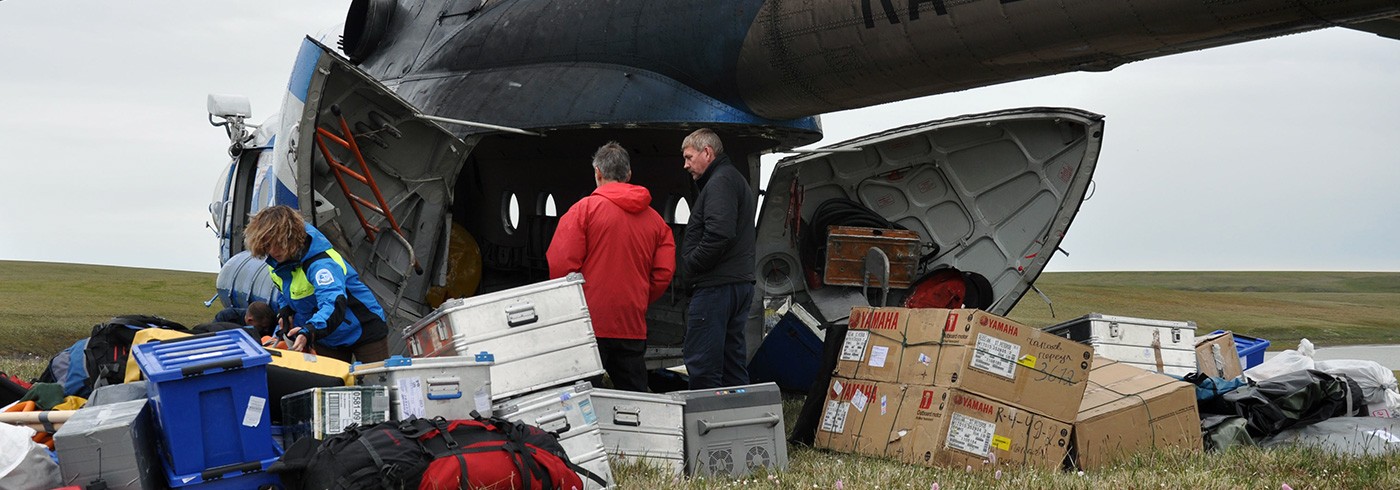
So, Friday morning it was time for take-off in beautiful weather. We packed our Mi8 helicopter – it became quite stuffed – and away we were shortly before lunch time. After a 2.5 hours flight, including a stop at depot 1 for letting off a barrel of gasoline for later use, we landed at our starting point in the upper reaches of the Luktakh River (~73°N, 92°E). We put up our Basecamp 1 on a sand plateau above the river, a flowering meadow in white, blue, violet, yellow and pink – the flowering is at places amazing and at its best just now. The weather had changed to overcast and we had some rain drops, but it was ok.

Unloading the helicopter: Photo: Per Möller

Basecamp 1. Photo: Per Möller
A chicken chilli and a few drops of vodka for expedition success finished off the evening, and most of us turned in at one o’clock.
Saturday meant a lot of work assembling the tree zodiacs, putting on the brand new motors and test-driving them. However, I myself sneaked away and had a first go at the geology of the area to get some impression of what we could expect. It is for sure not as in Bolshaya Balaknya in 2010 with its spectacular river sections; here we can only find smaller sections higher up in the valley slopes where sediments have slumped due to the, in the arctic typically very active, slope processes; hope it will get better further down-stream the Luktakh river!
Sunday was the first real workday; we travelled downstream with two zodiacs some 4 km where we found a 6 m high section in marine sediments. It became a dirty business: of course we got heavy rain on us and the whole thing more turned out to a mud wrestling game. But we got a nice section with clay, once deposited in deep water in a marine basin, followed by shallow water sand. And an abundance of molluscs for dating.

Sediments. Photo: Per Möller
We found out when coming back to basecamp, wet and hungry, that our nets had its first harvest for the expedition. There was lightly salted fish (sig; sik in Swedish) with onions and olive oil as a starter. And we roll into expedition week two tomorrow – more to come!
Per Möller, Lunds universitet

Photo: Per Möller