Prospecting camps for mineral resources and Arctic politics: the LASHIPA 9 expedition
31 July 2010 - 15 August 2010
Mining pick at the former entrance of an asbestos mine, Recherchefjorden. Photo: Pia Leminen
The objective of the expedition was to gather archaeological data from camps on Spitsbergen that were used for mining and prospecting by British and Dutch mining companies in the first decades of the twentieth century. How did these actors use the camps, land, and related resources, both commercially and politically? The collected data will be used within the LASHIPA project (Large scale historical exploitation of polar areas) in research dealing with:
- Technology design, architecture, and settlement plans in Arctic industrial communities.
- The international struggle for natural resources and political influence in the Arctic.
Over the last few years, circumpolar states have attempted to claim exclusive rights to portions of the Arctic seafloor within the framework of the United Nations Convention on the Law of the Sea (UNCLOS), but are also related to visions of future exploitation of possible natural resources. Understanding the current quest for Arctic resources and its political consequences calls for research into the history of similar past developments in the High Arctic. This is the starting point and rationale for the LASHIPA project.

Remains of a hunters hut used as a prospecting camp by a British mining firm. Photo: Pia Leminen
Mapping the mining
The expedition mapped remains of prospecting and mining camps at 20 sites in seven areas:
- East coast of Spitsbergen (Davis Harbour at Hedgehogfjellet)
- Sydkap
- Hornsund
- West coast of Spitsbergen
- Recherchefjorden
- Van Keulenfjorden
- Isfjorden.
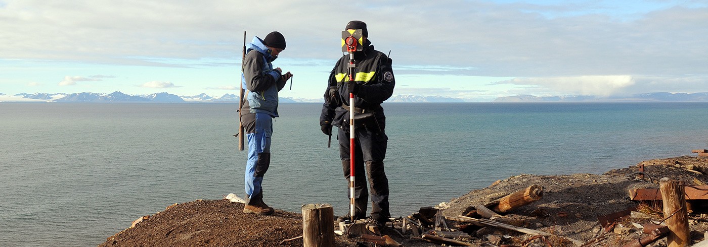
The team mapped most of the sites using an advanced GPS unit, and a hand-held PDA equipped with ESRI ArcGIS mapping software. Two sites – the HNMM Iron Range camp and Grumant city – were mapped using a total station. In addition, the team measured and drew most of the remains on the visited sites. All remains at all sites were photo-documented.

Map of the remains of a 17th century whaling station at Hornsund. Map: Dag Avango, mapped by Hidde de Haas

Total station map over the former
Total station map over the former
Soviet coal mining settlement Grumant city. Map: Frits Steenhuisen, mapped by Dag Avango, Hidde de Haas and Frigga Kruse
The remains of the camps indicate that most of them had originally been built by Norwegian hunters and trappers, who sold them to mining companies. The locations of these camps were not ideal for mining companies intending to open up large-scale mining: they were often located far from suitable mines and usually surrounded by shallow waters and jagged underwater reef systems, which would have made the shipping of ores very difficult and expensive. The general impression is that the mining companies used the camps only to defend their claims to possible mineral resources and land areas. The British mining camps are located at regular intervals along the Spitsbergen coast, forming the physical claim basis for almost the entire coastal zone of Spitsbergen. Given the low mining potential of most of these places, the camps likely also had a political purpose. They provided physical evidence of the importance of British assets in Spitsbergen, and could strengthen the mining companies’ lobbying vis-à-vis the British foreign ministry to claim sovereignty over Spitsbergen.
Accessible data
The fieldwork data from the LASHIPA expeditions conducted during the IPY are stored at the Royal Netherlands Institute for Sea Research (NIOZ). They will be publicly available starting in September 2012, after the publication of LASHIPA-related Ph.D. theses, journal articles, and a co-authored book.

Mapping of the former Soviet coal mining settlement by total station. Photo: Pia Leminen

Mapping of the former Soviet coal mining settlement by total station. Photo: Pia Leminen