Who has the rights to the seabed resources in the Arctic Ocean?
8 August 2016 - 20 September 2016
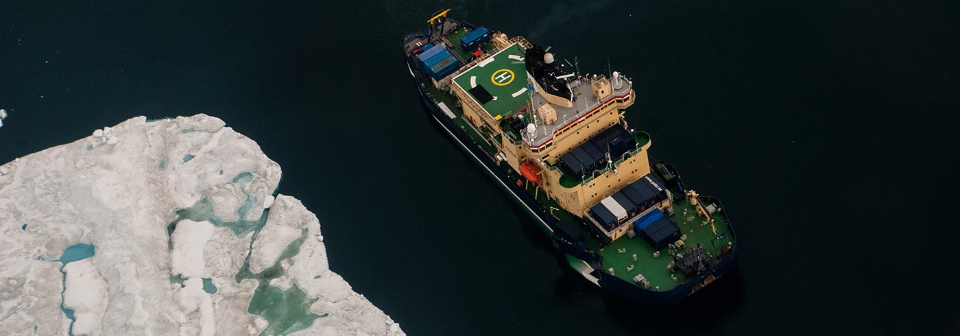
The Swedish research icebreaker Oden in the Arctic Ocean. Photo: Åsa Lindgren
The appearance and structure of the seabed can reveal a great deal about the history of our planet. It is the movement of the continental plates that has shaped the polar regions as we know them today. Just as on land, continental drift has created mountain chains and deep sea trenches on the seabed.
The seabed itself can be divided into a number of areas, of which the continental shelf is that part of the seabed that comprises the continental plate, i.e. that part of the continent that has been drowned by the sea. According to the United Nations Conference on the Law of the Sea (UNCLOS), coastal countries are entitled to extend an economic zone beyond their territorial areas. Within this economic zone, the country is entitled to the sea’s resources, such as the fisheries. The rights to resources on and below the seabed can extend further than the economic zone if the country can demonstrate that its continental shelf extends further than the economic zone, i.e. further than 200 nautical miles from the coast.
Swedish-Canadian collaboration
The Arctic Ocean is one of the least charted sea areas in the world. This is largely due to the fact that this area is difficult to work in, and that the equipment that is required in order to gather high-resolution data in ice-covered regions is extremely expensive. During the Arctic Ocean 2016 expedition, research was conducted as part of a Swedish-Canadian collaboration. The Canadian research programme focused on collecting data about the extent of the Canadian continental shelf in the Amundsen Basin and the areas around the Lomonosov Ridge and Alpha Ridge underwater mountain ranges. The data gathered will form the basis for Canada’s claim to the areas, which are an extension of the country’s continental shelf according to Article 76 of the United Nations Convention on the Law of the Sea.
By using two icebreakers, the Swedish icebreaker Oden and the Canadian icebreaker Louis S. St-Laurent, one vessel was able to focus on breaking the ice while the other could collect data. This proved to be a successful concept, resulting in extremely good, high-quality data.

Rocks retrieved by dredging. The rocks will reveal some information about the geological and oceanographic development of the Arctic Ocean. Photo: Åsa Lindgren
28,864 km2 of seabed were charted and sediment cores were retrieved from depths ranging from 855 to 4,367 metres
Using multibeam echosounders, a total of 28,864 km2 of seabed were charted, equivalent to an area the size of Albania. A multibeam echosounder is a measuring instrument that transmits hundreds of narrow beams of sound, each of which measures the distance to the bottom, thereby creating a three-dimensional image of the seabed. This measuring technique was supplemented in part with sediment echosounders, which transmit sound signals through the seabed to provide information about what is present up to 100 metres below the surface of the seabed. The water column was charted using sonar, and 13 sediment cores were retrieved from the seabed at depths ranging from 855–4,367 m. With the aid of the sediment cores and rocks retrieved by dredging, the researchers will gain clues about the geological and oceanographic development of the Arctic Ocean.
Ascertaining how the ice over the Arctic Ocean has changed through history
The same data that is used to chart and study the continental shelf can also be used to ascertain how the Arctic has changed during previous ice ages and warmer periods. Landforms on the bottom of the Arctic Ocean, formed by enormous volumes of ice, show how the inland ice sheets during glacial maxima continued out into the sea before subsequently retreating. Bottom sediment, rocks and fossils tell us about past climates and marine environments.
By understanding the parameters that govern the retreat of the ice sheets, researchers can produce better forecasts about what is going to happen in future.

In total 13 sediment cores were retrieved from the seabed at depths ranging from 855–4,367 m. Photo: Åsa Lindgren