LASHIPA 3 – Industry and its impacts in the polar areas from 1600 to present
7 August 2006 - 24 August 2006
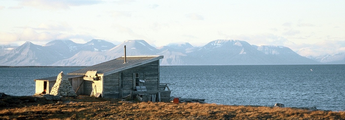
Bohemanneset – the site of the Dutch mining settlement of Rijpsburg, containing remains of mines, transportation systems and buildings. The site was mapped with total station in LASHIPA 3, August 2006. Photo: Dag Avango.
Introduction – research problems, methods and theoretical approaches
The circumpolar north has become increasingly important as a supply area for fossil energy, partly as a result of rising world market prices for crude oil and partly because of the possibilities for extraction and transport in the high north that global warming might offer. In the wake of this development, attempts have been made by states to establish exclusive rights to natural resources in the Arctic (AHDR 2004). No doubt national rights and sustainable resource management will stay on the agenda of international negotiations in the future. This is an important subject of the LASHIPA project – these developments call for research efforts on how actors have dealt with the natural resources, territorial rights and environmental issues in the polar regions in the past.
The LASHIPA project (Large Scale Historical Industrial exploitation of Polar Areas) is an endorsed and financed research project within the International Polar Year 2007–2008 (IPY), with participants from the Netherlands, Sweden, USA, Great Britain, Norway and Russia. It is multidisciplinary, with the emphasis on disciplines as Historical Archaeology and Industrial Archaeology. The aim of the project is to explain the development of industry in the polar areas from the 17th century until today and to analyse the natural and geopolitical consequences of that development.

Fieldwork locations in the Isfjorden region: 1) Kokerineset (17th cent. whaling station, 18th cent. hunting station), 2) Finneset (20th cent. mining and whaling), 3) Heerfjellet (20th cent. mining), 4) Bohemanneset (Rijspburg, 20th cent. mining), 5) Gipsdalen (20th cent. mining).
The LASHIPA project will analyse a set of research problems pertaining to industrial development in the Arctic and Antarctic. The first problem concerns the driving factors behind industrial development in the polar areas. We want to know what the primary driving forces were and what the necessary preconditions were. The focus here is on actors and changing historical contexts in the industrial centres of the world, from the 17th century until today.
Of great importance for general explanations is also the design of industrial activities in the polar areas. Thus a second research problem concerns transfer of technology and the design of technology. We want to know what strategies were used to adapt technology from the temperate zone to the harsh natural conditions of the polar areas. Also, why did the various national actors design their industrial activities differently? Was it a response to diverse natural conditions or a result of diverging industrial cultures? Why did some companies manage to adapt to polar area conditions and why did some fail? A third and closely related problem concerns the design of industrial communities and the social organisation of production. We are interested in how different national actors tried to establish social order under no-mans land conditions and harsh environmental circumstances. How did their strategies differ from each other and why? Did the design of company towns and the social organisation of production have an impact on the success or failure of industrial projects in the polar areas?
Since the 17th century, there has been a heavy competition over the control of natural resources of the polar areas. Therefore a fourth research problem concerns the strategies of different actors to establish and legitimize claims on natural resources – by using symbols and rituals of possession in the polar landscapes and in negotiations with competitors and between national governments. We believe that the choices of strategy had an impact on how successful the industrial projects were.
A fifth and closely related research problem concerns the consequences of polar industries for the geopolitical development in the polar areas. How were the activities of industrial companies used by national governments in struggles over the political status of the polar areas at different times? How did the industrial companies interact with the governments in their countries to strengthen territorial control? What was the role of rituals of possession and symbols of occupation in international negotiations? What was their impact on the international power relations in the polar areas?
Finally, an important research problem concerns the impacts of industrial activities on the local natural environment. We want to investigate and compare the local environmental impact of whaling, hunting, coal mining and oil extraction. With a comparative approach we will look at different attitudes towards natural resources before and after the industrial revolution, and different approaches to the natural environment between actors from different nations. What was the impact of these dissimilar approaches to the environment, and what can we learn from it?

Fieldwork locations in the Bellsund region: 6-8) NEC mining camps, 20th cent., 9) Van Muijdenbukta (17th cent. whaling), 10) Axeløya, 11) “Edge point” (17th cent. whaling and 19th cent. NEC activity), 12) Iron range (20th cent. mining), 13), Camp Smith (20th cent. mining, 17th cent. whaling), 14) Asbestodden (20th cent. mining), 15) Calypsobyen (20th cent. mining) and 16) Renardodden (17th cent. whaling).
LASHIPA consists of several subprojects that are carried out on different locations in both polar regions. LASHIPA will use two overarching theoretical approaches that will hold the different subprojects together – a core-periphery model and Actor Network Theory. The core-periphery model offers a general framework for understanding industrial activities in the polar areas. According to this model the polar areas can be seen as resource frontier regions because of their remote location and their production of raw materials for the industrial centres of the world. The activities in the resource frontier regions are always dependent on actors and historical contexts in the industrial cores (Sugden 1982, Hacquebord 1984, Duhaime 2004). However, since this model tends to focus attention on the core regions when explaining industry in the polar areas, we will also use a second theoretical approach – Actor Network Theory (ANT) (Latour, 1987, Law and Callon, 1992, Avango, 2005). ANT can be used to put the activities at the resource frontier into focus – human factors such as labour and knowledge, but also non-human factors such as geography, climate and material objects like technology, settlements and symbols. With this theoretical approach we can compare industrial projects within different branches, time periods, national origins, as well as in both polar regions, in a common analytical language. Moreover, the approach allows for symmetrical analyses of both traditional historical sources and archaeological data, thus allowing for synthesis and general conclusions.
Fieldwork
The research problems of the LASHIPA project cannot be dealt with solely by relying on analyses of written sources in archives, the traditional source of historical research. Analyses of archaeological data, environmental conditions and interviews with actors in the polar areas are of equal importance for understanding and explanation. This is especially true for the research problems concerning technology transfer, design of technology and of industrial communities, the social organisation of production and strategies for control over natural resources. Through archaeological investigations we can study how technological systems and industrial communities were designed and how these designs were influenced by local natural conditions. We can also analyse how natural resources were claimed through the use of symbols in the polar landscapes.
From this methodological point of departure the LASHIPA project will conduct several historical-archaeological field campaigns in the polar areas. Although the project will deal with polar industries in a circumpolar perspective, two areas have been selected for case studies – Svalbard in the Arctic (“The Green Harbor project”) and South Georgia in the Antarctic (“The South Georgia project”). These areas have been focal points for international competition for both natural resources and political influence over the course of their history, and they contain rich historical remains. Thus these are areas where the research problems of the LASHIPA project can be addressed in a limited geographical context.

Remains in Gipsdalen of a Scottish Spitsbergen Syndicate (SSS) mining- and claim marking site (from 1919). The remains of SSS activities on Bünsow land reveal both the industrial and colonial practices of this company. Photo: Dag Avango.
In line with this research plan a series of archaeological field surveys have been done on Svalbard – in August 2004 with a focus on the remains of American mining in the Longyearbyen and Isfjorden regions (LASHIPA 1), in August 2005 at Bohemanneset and Grønfjorden (LASHIPA 2) and in 2006 in various locations in the Isfjorden and Bellsund regions (LASHIPA 3).
The objective of the LASHIPA 3 survey in August 2006 was to find, identify and select sites on Svalbard that can be used for archaeological investigations during the International Polar Year. Our focus area was the great fjords of Western Spitsbergen – Isfjorden, Bellsund, Van Mijenfjorden, Van Keulenfjorden and Recherchefjorden. During the first half of the field campaign, the research team worked in two separate groups. One group surveyed and documented mining camps in Gipsdalen (Bünsow land) and the areas around Heerfjellet and Finneset at Grønfjorden. A second group mapped the remains of a coal mining settlement on Bohemanflya and a whaling/fur hunting station at Kokerineset at Grønfjorden. During the second half of the field campaign the two groups worked together in the Bellsund area. Field camps were successively established at Gipsvika, Gipsdalen, Bohemanneset and Kokerineset. A ship, Farm, was used as field camp at Heerfjellet, Finneset and in the Bellsund area.
The surveys were performed in a pedestrian reconnaissance mode: the researchers formed a line and searched a given areas for remains of industrial activities. All features and structures were recorded with either a TRIMBLE GPS (a highly accurate GPS unit with software adapted for mapping historical remains) or a total station (a very efficient mapping device with centimetre accuracy). Moreover, hand measure and hand drawn detail sketches were made of foundations, buildings and more prominent remains of industrial activities. All finds were photo-documented with Nikon digital cameras.
Preliminary results
The survey results provided the basis for a detailed plan for the field efforts during the International Polar Year. At Kokerihamna a highly detailed map of a whaling station and a hunting camp was made with the total station. The site contains the remains of two blubber ovens, several hut foundations and a number of graves. Our hypothesis is that the site was first established by whalers, most likely British or Dutch, in the 17th century and again reused by Russian fur hunters (Pomors) during the 18th century. During the IPY, in the summer of 2007, the plan is to excavate parts of the site with a team of Dutch, Russian and Swedish archaeologists.
A detailed plan for coming field efforts was also made for the eastern coastline of Grønfjorden. The remains of a 20th century whaling station at Finneset was surveyed and the results revealed a complex industrial structure with great potential for comparative analyses with contemporary whaling stations on South Georgia (archaeological investigations at Prince Olav Harbour are planned in the Austral summer of 2007–2008 or 2008–2009). In the summer of 2007 the site will be carefully mapped with a total station and interpreted with the help of written documents, site plans and historical photographs for establishing specific functions and for reconstructing the production line. The site will also be analysed in relation to the remains of a multitude of coal mines from the early 20th century along the same coastline – industrial facilities used as tools in the pre-Spitsbergen treaty struggle for control over the archipelago. Moreover, a major effort will be made in documenting the present mining town of Barentsburg – the settlement, the production line and its social organisation.

Camp Morton, a Northern Exploration Company coal mine at Van Mijenfjorden. Here we could study a British view on how coal mining in the Arctic should be designed. The site contains a production line with a coal mine high up in the mountain, a rail transportation system, coal stockpiles and reloading stations, a shipping area and living quarters for management, engineers and mine workers. The site was also used during spring time by Swedish workers in transit between the ice edge in Bellsund and the Svea mine (Sveagruvan) during the 1920’s. Photo: Dag Avango.
The LASHIPA 3 field campaign also gave conclusive data that can already now be used within the research project. In the Isfjorden region, at Gipsdalen on Bünsow land, we found and documented remains of transportation systems, several prospecting camps and a number of prospecting sites. These emanated from the activities of two different mining companies (and nations) and time periods – the Scottish Spitsbergen Syndicate (SSS) was active there in the early 20th century and the Finn Coal Development (FCD) was active in the mid 1980’s. One of the SSS sites was seriously threatened by erosion – a situation reported to the Norwegian heritage management authority on Svalbard. At Bohemanneset a detailed map was made of the remains from the early 20th century Dutch coal mining town of Rijpsburg. In the Bellsund region we mapped the remains of several mining camps and whaling stations. At Recherchefjorden we mapped the residues of a number of camps erected or just used by the Northern Exploration Company (NEC) from the UK, active in the 1910’s and 1920’s:
- the Iron range camp (built to investigate and mine supposed iron ore deposits in Martinfjella),
- Camp Smith (most likely used for the sole purpose of claiming the entire Recherchefjorden area for the NEC, since there is hardly anything to mine there), and
- Camp Calypso (a settlement for coal mining and radio communication).

Wouter Ytsma, University of Groningen, mapping a mining camp with total station – a highly accurate instrument used for mapping archaeological sites. Photo: Dag Avango.
Remains of NEC activities were also mapped at Edge point. Moreover, two whaling sites were mapped in the area, at Camp Smith and at Renardodden. In Van Keulenfjorden an attempt was made to map a NEC prospecting camp (originally a hunters’ hut). However the effort was hampered by the presence of no less than four polar bears in the vicinity. On the northern side of Bellsund several prospecting and mining camps, also emanating from NEC activities, were mapped – Camp Bell and Camp Millar. At Camp Millar a previously unknown mine was documented. At the mouth of Van Mijenfjorden, a detailed map was made over the Camp Morton coal mine (NEC) with the total station – including a transportation system and several mine openings situated in a very steep and unstable location high up in the south face of Kolfjellet. The archaeological data from the sites investigated during the LASHIPA 3 expedition provided the project with important data for comparative analyses on several of its research problems – technology transfer, the design of technology, the shaping of industrial settlements and the strategies for claiming and controlling natural resources. The cases provide data for international comparison between different time periods, between different national actors and between different regions in the polar areas. Last but not least, the results of archaeological surveys are not only what you find but also what you do not find. During the surveys, we expected to locate the remains of 17th century whaling sites in at least two areas in the Bellsund region, where written sources seem to indicate that whale hunting was performed – the Van Muijden Bay and the west coast of Axeløya. Despite thorough reconnaissance efforts, no traces of whaling remains were found. However observations of landscape settings and other natural conditions gave important insights into both the physical realities of 17th century whaling and into the natural processes eroding cultural remains in the vicinity of coastlines, thus providing important data for dealing with the research problems of the LASHIPA project.