Where the northernmost world ends – fieldwork in Johannes V. Jensen Land on its glacial and palaeoenvironmental history - part 1
6 July 2006 - 15 August 2006
Overview map of Greenland. A) Coloured box indicates insert map, B) shows our four principal investigation areas on the northern coast of Johannes V. Jensen Land
Background
The importance of the Arctic region for global change has often been stressed in recent years, both in the scientific community and in the media. A cold arctic region with an ice covered Arctic Ocean has been suggested to be crucial for a North–South climate gradient sufficiently steep to drive the meridional energy exchange, which again is an integral part of the Earth’s climate today. The risk is that rapid greenhouse warming may destroy this. However the case for rapid change rests to a large extent on satellite observations and – in the case of rapidly diminishing sea ice – from measurements made by nuclear submarines over the last 30 years. There is therefore a need for an assessment of the long-term “natural” variability of such complex and powerful agents as sea ice and glaciation along the Arctic Ocean coast.
Greenland’s north coast is the northernmost land in the world, and one of the few remaining coastlines still facing permanent sea ice cover. Owing to its inaccessibility it is also among the world’s least explored regions. The LongTerm project has been launched in order to perform a broad spectrum investigation of the interactions between climate, sea ice cover, and glaciation over a time scale ranging from the Holocene and back through the last glacial cycle, aiming to contribute to a long-term record of the variability and sensitivity of this extreme environment. The changing conditions for Greenland’s earliest cultures are also considered in the project. LongTerm was initiated by Svend Funder at the Geological Museum in Copenhagen, Denmark, who also is the principal project leader. Due to the long-standing cooperation between the Geological Museum, the Department of Geology at Copenhagen University and the Department of Geology at Lund University, the Swedish group of glacial geologists was invited to take part in the project’s work in 2006, which is also a part of SWEDARCTIC 2006 (the Swedish Arctic Research Programme). The LongTerm project is a precursor to the APEX project (Arctic Palaeoclimate and its EXtremes), which has been named a ‘lead project’ for International Polar Year 2007–2008 (IPY). The APEX project is planned to unfold in and along the Eurasian and Greenland Arctic Ocean in 2007 and 2008.

Preparing lake coring in Bliss Lake; a 3.4 metre long sediment core was retrieved from this lake – a Greenland high-arctic record. From left to right: Per Möller, Nicolaj Krog Larsen, David Mazzuchi andKurt Kjær. Photo: Svend Funder.
Aim and scope
The target for fieldwork was the coastal plain along the Arctic Ocean, its tributary valleys and valley glaciers (figure 1). With altitudes below 100 m and a width up to 20 km, this coastal plain fringes the Arctic Ocean for ~100 km in Johannes V. Jensen Land. Unique to Greenland, the plain probably originated as an ancient marine abrasion terrace. It is covered by a continuous blanket of Quaternary sediment, and reconnaissance fieldwork in the snow-melt season has indicated that it contains a record of glacial and marine events and sea level change going back more than 40,000 years (Funder and Hjort, 1980, Funder and Larsen, 1982, Dawes, 1986). The aim of the LongTerm project is to study sediments, landforms and lakes – but also remains of former human habitation – on the coastal plain and along valleys leading into the alpine mountains to the south, supplemented with studies on processes along present glaciers. More specifically the project aims at:
- The establishment of a glaciation record for northernmost Greenland and investigation of the dynamic interplay between alpine and ice sheet glaciations and their sensitivity to changes in sea ice cover.
This will be achieved by surveying present valley glaciers and sedimentological processes along their margins, combined with installation of data loggers. Additionally traditional field mapping of landforms and logging of sediment sections combined with analyses of glacial geomorphological elements in satellite imagery and aerial photographs will provide a record of past glacier behaviour.
- Reconstructing the sea ice and sea level history of northernmost Greenland.
This will be achieved by studies of raised marine sediments on the coastal plain and on wave- to non-wave generated beaches. Important information on these aspects is also obtained from the dating of driftwood, as this is an indication of both open water along the coasts and of partially open water along the passage in the Arctic Ocean.
- The establishment of a precise chronology of the environmental change.
Precise dating is a prerequisite for all types of records. Here we use the same methods that we developed during our QUEEN project in northern Russia for dating similar records: AMS 14C-dating of organic remains, OSL (Optically Stimulated Luminescence) datings of sediments, and exposure datings of rock and boulder surfaces by 10Be and possibly other cosmogenic nuclides.
- Tracing the human environment in the extreme north.
In spite of an arctic desert environment and a five month polar night, the area has an archaeological record showing all major phases of human habitation in Greenland, going back approx. 4 500 years (Grønnow and Jensen, 2003). The plans were to professionally excavate some observed palaeoeskimo ruins and reconnoitre for new ones. Further the aim was to trace human DNA in frozen soil to show ethnic roots of early immigrants and to carry out exposure datings on ruins and tools.
The fieldwork
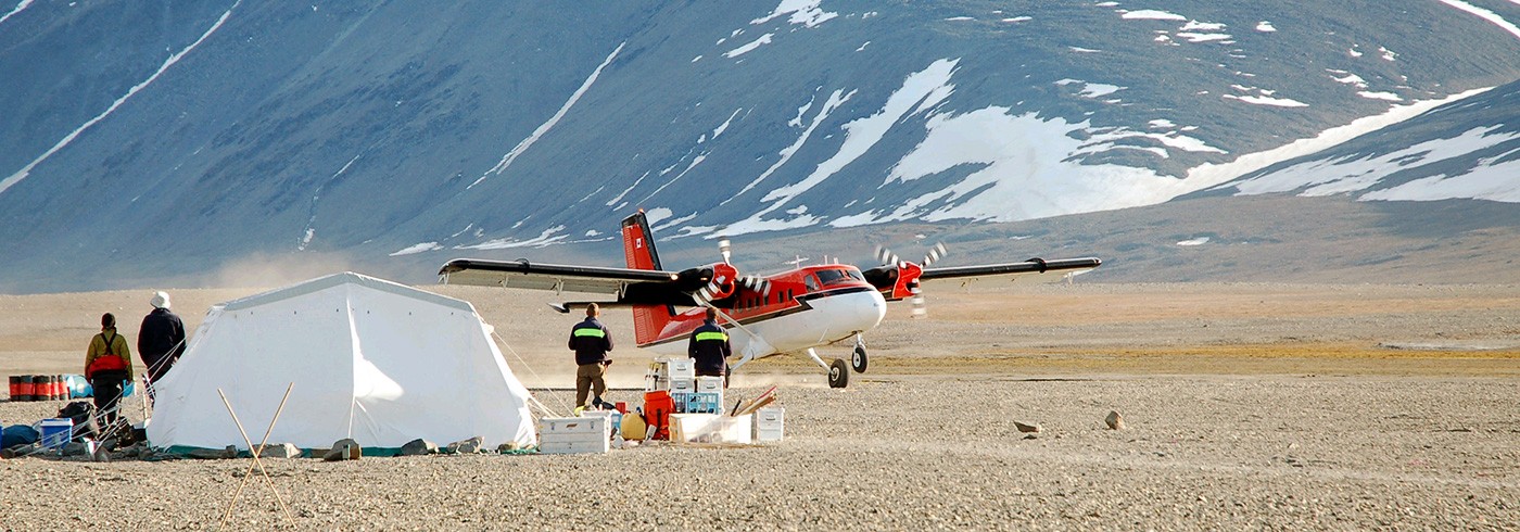
The LongTerm expedition in 2006 was part of a larger field campaign set up by the Danish Polar Centre under the name of “Forskning i Nord” (Research in the North), with a logistic platform based on Station Nord (81°43’N, 17°50’W, figure 1B). The LongTerm field party went by regular flight on 6th July from Copenhagen to Longyearbyen, Svalbard. Due to bad weather the group had to stay in Longyearbyen for a couple of days, but was eventually flown across the Greenland Sea to Station Nord in the evening of 9th July by a Canadianchartered Twin Otter. Due to bad weather, helicopter operations from Station Nord had not been possible for a week and the station was thus quite crowded with field parties waiting to get out. Logistical problems increased as the helicopter crashed while returning from the first delivery of researchers to the field. Though the helicopter was totally wrecked, the pilot was fortunately unhurt. Lacking any helicopter replacement until 29th July, we had to depend on Twin Otter transport which, together with unusually large snow cover on the terrain, meant a rethink of the possible landing/camp sites as compared to the original expedition plan.
After seemingly endless waiting at Station Nord, the whole group was deployed on 13th July in two Twin Otter flights to the first field camp at Constable Bugt, the camp situated some 3 km from the coast at 83°34.36’N, 32°1.55’W (figure 1B). Camp was set up on a gravel bar close to the river (picture 2). However one question dominated our minds: What on earth are we doing in a place like this? It was +2°C with a bitter northern wind carrying snow in our faces, and the clouds were just 50 m above us. We were supposed to stay in this area for some five weeks, being the absolutely most northern men and woman with land beneath their feet, around 700 km from the North Pole. And we all knew that southern Scandinavia had the best summer for decades with temperatures around +30°C, week after week! However, as it turned out we repeatedly got periods of 3–6 days with very stable weather conditions including lots of sun and nice “summer” temperatures between +6–10°C, interspersed with low-pressure passages of rain and/or snow for a few days. The Constable Bugt valley also turned out to be the ‘garden of Eden’ of the expedition, compared to the truly arctic deserts of our other field camp sites. After some days of sun the barren ground exploded in the colours of arctic poppy, Dryas and different kinds of Saxifaga. Muskoxen, geese and arctic hare were abundant everywhere, and the arctic tern with its nest on our landing strip fought us courageously on our way to the toilet.

Our first camp in the Constable Bugt valley. Photo: Per Möller.
Our group of glacial geologists was really kept busy: numerous sections along the river valley exposed glaciolacustrine sediments terminating on the proximal side of a large terminal moraine from a valley glaciation. River-cut cliffs in this moraine in turn exposed a complex sequence of tills and sorted sediments deposited in interaction between a valley-based glacier and a shelf-based glacier to the north. Along the coast numerous sections exposed raised marine sediments and beach deposits.
Still having no helicopter replacement, our plans had to be changed. Instead of a split into two different camps the whole group was shipped by Twin Otter some 60 km eastwards to the eastern side of Bliss Bugt (figure 1B) on 23rd July (picture 3). After serious reconnaissance the plane landed on the only possible landing strip(?) – shaken, not stirred – far from any sections of interest to a glacial geologist! For the following ten days there was plenty of time to study a ground moraine landscape most probably formed by an east-flowing shelf-based ice sheet. The till surface was loaded with large boulders, some of them from a clearly western source area, carrying striae from the west. With a lot of time to spare, glacial geologists turned to the lake coring programme. This had so far met with little success, having encountered only shallow lakes with very little sediment. However at Bliss Bugt we localized a lake with water depths up to 9 metres. From this lake, but not without some effort, a 3.4 m long sediment core was retrieved, containing laminated sediments (probably glacial varves) with a substantial content of organic detritus (picture 1). Pending 14C-dates will show the importance of this, for these High Arctic conditions, very long core!

Twin Otter landing at the Constable Bugt camp before transfer to the Bliss Bugt camp. Photo: Per Möller.
After a period of stormy weather and snow, the helicopter finally arrived and lifted the expedition to new and final sites on 2nd August. The glacial geologists were split into two different camps at Moore Glacier and along the Kaffeklubben Elv, respectively (figure 1B), while the rest of the expedition members were flown with Twin Otter to successive camps at Kap Ole Chiewitz and at Mågefjeld on Holm Land in the quest for palaeoeskimo ruins. At Moore Glacier we studied glaciological and geological processes along the margin of a modern higharctic glacier, as well as processes on pro-glacial outwash fans. Climate stations were also set up for monitoring air, surface and below surface temperatures, and precipitation. The area around the Kaffeklubben Elv revealed rich records of deglacial geomorphological and sediment sequences and very well-exposed sections of raised marine and beach deposits. Thick sequences of marine silt of yet unknown stratigraphic position were also encountered. Pending datings will probably resolve this.
The whole expedition party was successively reunited at Station Nord on 12th–13th August. After sorting out the samples and packing all expedition gear, we were flown to Longyearbyen on 15th August and finally back to Copenhagen the day after. And the 42 day long expedition was over!
Some conclusions
Even though the expedition did not follow the initial plans due to the difficulties in transport logistics and unusual snow coverage at some sites, the geological investigations carried out were a success. The sediment sequences investigated from the Constable Bugt, Kaffeklubben Elv and Bliss Bugt areas will give us information on the interaction between local mountain/valley-based glaciers and more regional ice sheet coverage on the plain/shelf areas to the north. However, as no datings have yet been received, it is premature to put the environmental history into a chronological framework. One of the most interesting observations is the occurrence of fossil high-energy beach systems. These suggest open water during period(s) of the Holocene, as opposed to the present day conditions with permanent sea ice along the North Greenland coast. This puts the present-day discussion of fast ice degradation over the Arctic Ocean into perspective. It has been argued that the possible disappearance of sea ice from the Arctic Ocean due to global warming will be an irreversible environmental change. However, our findings indicate that open-water conditions along the North Greenland coast has at least once during Holocene time flipped back into frozen Arctic Ocean conditions! Even if not yet dated, we presently suppose that these open-water conditions occurred in the early Holocene, thus tied to the insulation maximum at that time.