Expedition summary: Beringia - changes in climate and ecosystem
5 July 2005 - 25 September 2005
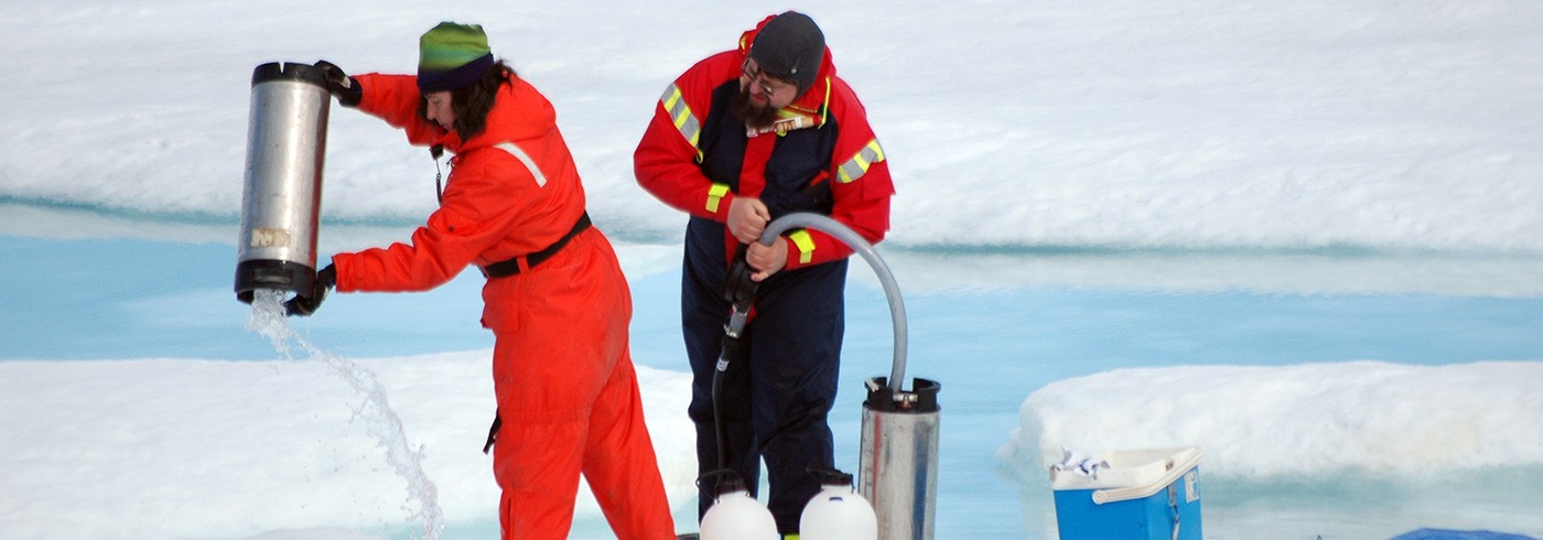
Collecting water samples from a melt water pool on the ice. Photo: Gunnar Kihlberg.
Beringia has unique terrestrial and marine environments, and there is a growing concern for how this region is affected by climate change. The icebreaker Oden’s travel from Scandinavia and back during the Beringia 2005 expedition gave opportunities for marine and atmospheric science projects focused on the role of this region, and the entire Arctic Ocean, in the climate system. This addressed such diverse topics as water circulation patterns, geophysics, atmosphere–ocean interactions and landshelf–basin interactions. The theme covered three legs with Oden; the Canadian Arctic, the Bering Strait region and the central Arctic Ocean. The third leg was performed in close co-operation with ocean floor mappings performed by Swedish and American geologists onboard the icebreaker USCGC Healy.
The oceanography around the Bering Strait is of great importance, being an apex of interactions between the Bering Sea and the Arctic Ocean which may affect climate change. This was investigated by a combination of physical and chemical oceanography, and atmosphere analysis. The direction and magnitude of water currents at different depths largely determine the movements of material, gases and temperature gradients through the ecosystem. One study focused on the formation of the halocline, the important layer separating saline seawater from fresher surface water. Major rivers flood the Arctic Ocean with fresh water and terrestrial material. Outside the immense Mackenzie River delta, for example, river water was present in large amounts even 100 km from the coast. The sea ice also acts as a vehicle for longdistance transportation of sediments. The extent and nature of this flux of elements from land to the shelf seas and further on into the ocean basin can have profound implications. For example coastal erosion in the Beringia region can wash away the coast by up to 3 metres per year! Such a huge input of terrestrial organic carbon to the Arctic Ocean could dramatically alter biogeochemical cycles, causing a positive or negative feedback to global change. Some of this carbon is also consumed by microbial activity, which was another aspect investigated during the expedition. Intensive biological production was found in the Arctic surface waters. Furthermore, water conditions affect gas exchange between sea and air, which in turn determines the level of greenhouse gases, such as carbon dioxide, in the atmosphere.
There is also a growing awareness of the importance of the exchange and transport between land, ocean and atmosphere of toxic elements such as mercury, PCB and brominated flame retardants. Most of these substances originate from human societies at more southerly latitudes and accumulate to dangerous levels in Arctic top predators: seals, polar bears and humans. Mercury levels were found to be very high in and above the ice-covered waters of the Canadian archipelago and the Arctic Ocean. Other chemical compounds destroy crucial atmospheric features such as cloud formation capabilities and the ozone layer, exposing the Earth’s surface to higher levels of UV radiation. Man-made organic halogens are for very good reasons an important focus of environmental protection programmes, yet large quantities are also released into the atmosphere by natural processes in algae. This was examined in sea water, ice and melting ponds across the Arctic Ocean.
Studies of paleoecology, or ecological history, here presented under other scientific themes, also give important keys to the relationship between climate and ecosystems. By understanding how the composition of plants and animals have changed with previous glaciations and warm periods we are in a better position to predict future effects of climate change. Advanced measurements of gas flux and solar radiation were made in the field to assess how greenhouse gases interact with the tundra. These analyses, together with plant surveys and other ground measurements, will be compared with satellite photos and historical records to investigate the extent and effects of recent changes in the tundra landscape.