KINNVIKA – A multidisciplinary and multinational platform for arctic warming and impact research during the fourth International Polar Year
1 April 2008 - 31 August 2008
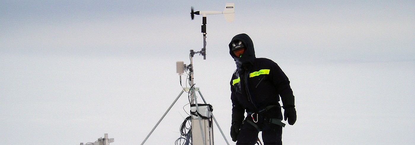
Ulf Jonsell at the AWS on Vestfonna. Photo: Veijo Pohjola.
Background
The International Council for Science (ICSU) has declared 2007–2009 the fourth International Polar Year, marking the 50-year anniversary of the last Polar Year. It is anticipated that technical developments will permit many novel ways to study the polar areas, and a specific focus will be upon concern that the global warming we are witnessing today will bring large effects to the polar areas. On the Nordic horizon, representatives of the Nordic countries’ polar authorities have formulated this into a question: will the Arctic survive in its present form? And furthermore, how will changes in the Arctic influence the global climate, and are the signals read today truly persistent?
Records accumulated over the past decades provide ample evidence that the warming of the Arctic is a fact, the most striking change being characterized by the decrease of the Arctic pack ice. Without doubt, the continuation of this transgressive trend will have a significant impact on Arctic ecosystems as well as on human societies in the Artic region. According to the predictions generated by models of the Earth’s climate system, one of the most vulnerable regions of climatic change in the Arctic is the northernmost Atlantic Ocean, an area including the Greenland and Barents Seas, and the adjacent Svalbard Archipelago. The reason for this is the excess of heat from the tropics that is advected by the North Atlantic Drift up to latitudes of 80°N, which produces large shifts in the edge of the Arctic Ocean pack ice between cold and warm years, a phenomenon further corroborated by the fact that the largest pull-back of the Artic Ocean sea ice is normally in this sector. Consequently, the Svalbard Archipelago provides a suitably strategic position for the task of recording information on the current direction of changes.
Since Svalbard forms the northernmost land in the European sector of the Arctic, and Nordaustlandet is the northernmost larger terrane in Svalbard, it is likely that changes in progress in this location will propagate southwards, both as physical processes and as a result of economical and political feedback, which makes the changes occurring in this region of utmost relevance for the Nordic countries. Important scientific questions to focus on are:
- Climate change and impact research
- Climate- and environmental monitoring
- Mapping of bio- and geosystems
- The history of human activities and settlements in the High Arctic
- Outreach and Education
The Svalbard region has been the focus of Nordic polar research for a considerable length of time. The French corvette La Recherche that navigated the Svalbard waters between 1838 and 1840 carried a handful of Nordic scientists, and with the expeditions conducted by A.E. Nordenskiöld to Svalbard during the first polar year 1882, research in this area has been characterized by a tradition of Nordic influence. From a Swedish perspective commitments during the two first polar years were solidly focused on Svalbard. For the third polar year in 1957, Swedish, Finnish and Swiss scientists and authorities received permission from the Norwegian Governor of Svalbard to build a research station in Murchinson Bay, then called the SFS-station after the participating countries, and later renamed as the Kinnvika station. The main objectives for building the station on Nordaustlandet were most probably similar to the objectives we have today: to put a monitoring station as far north as possible in the High Arctic. The short distances to larger and seasonally ice-free ports, and the relative warm conditions in the west of Nordaustlandet, have been a deciding factor both now, and then. This station dating from the previous polar year has been used as the centre of our polar year project and apart from providing superior shelter from weather and scavenging animals in comparison to temporary camps, it also facilitates storage space for long-time depots and the necessary work shops for maintenance and scientific work.
We are today roughly 55 scientists engaged in the KINNVIKA project. A majority of the attendees are from the Nordic countries, and we also have a strong component of Polish participants.
General project outline for IPY-KINNVIKA
Our focus is on research activities that fall within the framework of the IPY on the High Arctic island of Nordaustlandet, the northernmost major part of the Svalbard Archipelago. The island is 90% ice-covered, and polar desert and semi-desert ecosystems, underlain by continuous permafrost, dominate the unglaciated terrain. Because of its position, the climate in Nordaustlandet is substantially more influenced by arctic air and therefore more extreme than the other parts of Svalbard. We chose Nordaustlandet as our study site for several reasons:
- Being the northernmost sizeable terrestrial platform in the European sector of the Arctic, Nordaustlandet is the area that will first be subject to the large sets of changes generated by warming that has already been sensed and that is expected to continue in the future.
In contrast to a variety of extensive research and monitoring activities in southern and western Svalbard, very little research has focused on the northeastern part of Svalbard during the last decades. This is probably due to difficult access and logistics. However, large gradients in climatic and environmental regimes across Svalbard are to be expected while the relatively small impact of the human footprint in the area constitutes another important reason to conduct an IPY project on Nordaustlandet.
- Being farthest away from Eurasian pollutant sources and from the influence of the northeastern North Atlantic Drift, Kinnvika can provide unique monitoring of meteorological and environmental parameters.
Several IPY programmes are active in the monitoring of meteorological and environmental parameters. On Svalbard the sites established for these activities are Hornsund, Longyearbyen and Ny-Ålesund, all three located on the island Spitsbergen. Kinnvika therefore offers a complementary platform that will extend the monitoring network over Svalbard, by adding a northeastern tangent. Kinnvika constitutes the location of most significant arctic influence among the various stations, which is important for analysis of gradients across the archipelago.
- Being sparsely studied, Nordaustlandet is relatively poorly mapped in regard of ecosystems, terrestrial deposits and geological sequences.
Nordaustlandet is a national park implementing the strictest environmental policy in Svalbard, a factor that has restricted extensive taxonomical and geological exploration on the island. Consequently, while environmental policy has preserved pristine environments, it has also hampered the mapping of the area.
- Svalbard plays an important part in Nordic polar history, and Nordaustlandet has featured as a centre for whaling and hunting activities, as well as the early polar exploration efforts.
Traces of these activities will be set in perspective to the environmental data we gather, and in this way used as keys to understanding the human activities of the past, and perhaps also give a prediction of how human activities in this Arctic archipelago may change in the future. In general, our initiative provides a broad scientific and logistic platform around which a number of research and monitoring activities may be performed in a truly interdisciplinary manner. Due to difficult access and logistics in this remote northern part of Svalbard as compared to the southern and western areas, we consider the framework of IPY ideal, if not essential, for dedicated, effective, multidisciplinary and international research and monitoring collaboration of Nordaustlandet.
Summary of KINNVIKA activities 2007

Picture of the Kinnvika station from MS Farm September 2005. Photo: Veijo Pohjola.
Two KINNVIKA expeditions were launched in 2007, totally comprising 29 persons and 383 man-days at Kinnvika. In this report we will provide a brief summary of the overall operations. More detailed reports are found at www.kinnvika.net and reports from the Swedish scientific teams are included at the end of this report.
The first expedition was between 19 April and 10 May and comprised four glaciologists: Emilie Beaudon and John Moore from the Finnish University of Lapland, and Veijo Pohjola and Ulf Jonsell from Uppsala University, who were flown in and out by Airlift helicopters from Longyearbyen. The bulk of the equipment was shipped in by RV Lance by the kind assistance of colleagues from University Centre in Svalbard (UNIS) one day earlier. In short, the activities were focused on the ice cap Vestfonna, where an automatic weather station (AWS) and a large number of mass balance and ice velocity position markers were installed. We also took snow samples in two snow pits and drilled two shallow ice cores (12 and 6 m deep) as a pilot study in order to investigate the information potential in the ice archives for planned deep ice core drillings during spring 2008.
The second expedition was brought to Kinnvika by the Polish ship RV Horyzont II on 28 July and the last personnel were shipped out from Kinnvika by MS Farm on 21 August. The summer expedition involved a total of 26 persons. Seven helicopter flights, from Airlift and from IB Oden/Kallaxflyg, transported personnel between camps on Nordaustlandet and between Longyearbyen and Kinnvika. Most of the science projects used Kinnvika as a base, but one of the projects utilized a satellite camp at Snaddvika ca 20 km southeast of Kinnvika. After the arrival of RV Horyzont II in Kinnvika roughly 10 tonnes of cargo were unloaded and landed at the beach for transport and storage in the Kinnvika station, to form the backbone for the coming expeditions. It is interesting to note that this amount of cargo is dwarfed by the 500 tonnes that HMS Älvsnabben brought to Kinnvika in 1957, to supply the station for one year of activities during the previous polar year.
There were two outreach projects, which were permanently based onboard the ship: A team from Swedish TV4 made reportages of the expedition, the old station and about the status of global change in general for news documentaries. They filmed the debarkation of the equipment and setting the station to life, as well as interviews with participating personnel. The reports were later aired on prime time TV4 news over one week in the early autumn, and the issues studied in Kinnvika were placed as primary issues in the news hierarchy. The other outreach project was part of a larger approach making a full sized documentary film about the interaction between humans and nature in the High Arctic. A team from the Finnish film production company WildFin documented the initial stages of the build up of the station, and they will probably be back in the coming years to gather more footage.
When RV Horyzont II left Kinnvika the seven different projects started their operations:
• A study of black soot and microbes in cryoconite holes on the Vestfonna ice cap, by Carl Egede Bøggild from UNIS and Andy Hodson from University of Sheffield. The aim was to study how small melt pools on glacier ice interact with changes in albedo and therefore influence glacier melt. Their specific interest was to find how microbial life and atmospherically derived soot determine the properties of the cryoconite holes.
• Vestfonna glaciology by Ulf Jonsell from Uppsala University and Olli-Pekka Mattila from Helsinki University. Ulf Jonsell and Olli-Pekka Mattila conducted maintenance on and downloaded data from the weather station, surveyed the mass balance station and installed spectrometers at the stations.
• Sedimentology and stratigraphy in Murchinson Bay, by the Helsinki University team Veli-Pekka Salonen, Anu Kaakinen and Frauke Kubischta. The team scouted and mapped glacial stratigraphical sequences along the coasts of Snaddvika and Heimbukta, and has reported at least three documented glacial advances in southeast Murchinson Bay, over land that today is ice-free.
• Pollution in Kinnvika. The Kinnvika station was sampled by Bartek Luks, from the Polish Academy of Science to analyse the amount of metallic and ionic contaminants. The aim is to investigate how the level of contaminants accumulated during the previous expeditions has changed in comparison with levels recorded during our expedition.
• The geodetical net of Kinnvika was surveyed and improved by Leszek Kolondra from the University of Silesia, which will result in the production of an orthophoto map of Kinnvika and Vestfonna.
• Invertebrate and vegetation diversity of Murchinson Bay was studied by Steve Coulson, Elisabeth Cooper, María Luisa Ávila Jiménez and Allison Bailey from UNIS whose objective was to produce a taxonomical map showing the occurrence of flora and invertebrate species in the area. The biology of Nordaustlandet is poorly described and preliminary results indicate far more life than is preliminarily assumed by viewing this cold and barren High Arctic landscape.
All the projects described above are ongoing and we expect approximately 55 scientists to be involved in KINNVIKA expeditions during the coming two years. During the spring about half of this number will be participating in glaciological projects in the ice cap Vestfonna. The rest are involved in projects that will be in progress in Kinnvika next summer, partly shipborne projects utilizing RV Horyzont II, and partly terrestrial projects.
Glaciology on Vestfonna, by Ulf Jonsell and Veijo Pohjola
The glaciology projects on Vestfonna under IPY-KINNVIKA are encompassed in the overall project “State and fate of the ice cap Vestfonna” which links the work within the IPY project GLACIODYN and the focus on the dynamic state of the Svalbard ice masses. Regional models predict that the average warming over the High Arctic is likely to be in the range of 5–7°C during the present century. The current rate of sea level increase is 3.2 mm/yr, which is attributed to a large extent to the melting ice caps. In respect of the projected increase in warming of the Arctic, areas closer to the advection pathways of heat will initially be more affected than areas more isolated to the exchange of heat. Svalbard constitutes such a sensitive area, due to the proximity to the North Atlantic Drift, and may be expected to display considerable changes with future warming.

Map of Svalbard, Nordaustlandet, the ice cap Vestfonna and Kinnvika. ©Norsk Polarinstitutt.
Svalbard is to a large extent glaciated, with the amount of glaciation increasing towards the northeastern part of the archipelago (figure 1), due to the predominant easterly airflow during precipitation events. The total ice coverage of Svalbard constitutes twice the ice coverage on the rest of Europe (including Iceland) and stores ~5 cm of global sea level. The largest proportion of this ice is stored in the Nordaustlandet ice caps Austfonna and Vestfonna.
Our group is made up of roughly 20 glaciologists from different countries that will focus on the glaciology of Vestfonna over the polar year. This year’s expedition was to pave the way for the larger expeditions, scout safe routes and make basic installations that will be utilized during coming years of activities. These installations comprised one automatic weather station (AWS) placed on the western slope of Vestfonna at 330 m a.s.l. (figure 2). We further drilled 29 aluminium stakes into the accumulation and ablation areas of Vestfonna to be used as markers to determine mass changes over the ice cap during the runtime of the project. These markers will also be used to determine the ice flow of the ice cap, as shown in figure 2. The markers were measured after drilling using differential GPS to give positions with cm precision. We also levelled the surface of Vestfonna during the transport with snowmobiles between the mass balance/GPS markers using kinematic GPS. This levelling “on the go” can be compared with earlier measurements on topogra-phic maps and from air borne laser levelling that was conducted by colleagues in 1996 and 2002. Preliminary data shows that the summit of Vestfonna has decreased some 30 m since the previous polar year in 1957, and that a third of this decrease may have taken place during the last decade.

The Ice Cap Vestfonna, snowmobile routes and the stations placed on the ice cap during spring 2007. The arrow marks the AWS described in the text.
The AWS is equipped in order to obtain data for energy balance calculations and carries sensors for air temperature, relative humidity, short and long wave radiation, wind speed, wind direction, and relative surface height. Snow and ice temperatures are measured at even 0.5 m intervals down to 9 m depth. The energy fluxes at the glacier surface can be quantified from the AWS data and by calibration with the measured ablation this data will be used to construct an ablation model for Vestfonna ice cap. The AWS was revisited in early August and four months of data was downloaded (figure 3). Sensors and loggers had been working properly and the data is of very good quality. Powered up with new batteries, we hope to have a full year of data after the next field visit in April 2008. In addition to the AWS, a temperature sensor was installed in April at the summit of the ice cap in order to obtain temperature lapse rates on the ice cap, which will be used in forthcoming distributed ablation modelling.

Hourly mean air temperature, wind speed, relative humidity wind direction from the Vestfonna AWS (preliminary data).
The constant ice temperature depth was located at 8 m with a temperature of -7.0°C. The ice above the constant temperature depth increased on average 2.5°C during the period of melt. In an ablation model of a cold glacier (i.e. ice temperatures are below 0°C) the energy surplus at the glacier surface must be apportioned between the ice heat flux and the snow and ice melt flux. Results from preliminary energy balance calculations based on the data available so far show that a proportionally high energy flux is used for heating the ice, probably because of substantial refreezing of melt water at the ice surface with the subsequent release of latent heat.
The meteorological data from the AWS will, when longer time series are available, be used to construct transfer functions between reanalysis of meteorological data (i.e. historical meteorological data processed and interpolated into grid cells with modern forecasting techniques). The objective is to reconstruct historical ablation rates and mass balance by driving the mass balance models with reanalysis data. A preliminary comparison between the NCEP/NCAR reanalysis surface air temperature data (Kalnay et al. 1996) and the so far available temperature series from the AWS, show surprisingly good correlation (figure 4), considering that the reanalysis data is obtained from interpolation into 2.5°×2.5° grid cells.

6-hourly mean air temperatures from the Vestfonna AWS (black line) and NCEP/NCAR reanalysis surface temperature (grey line) (preliminary data).