Dating the onset of regional glaciation in Northeast Greenland
16 August 2003 - 6 September 2003
A moraine ridge on the southern Store Koldewey lowland, probably dating from the end of the last glaciation. Photo: Lena Håkansson
Introduction and scientific background
For a long time the onset of regional northern hemisphere glaciation was thought to date from the Quaternary time period, that is from within the last about 2 million years, while glaciation in Antarctica was well documented from far back into the preceding Tertiary period. However, today results from both terrestrial geological work (e.g. Funder et al., 2001) and marine geological studies (e.g. Thiede et al., 1998, 2001) document extensive late Tertiary glaciation also in the north. The indications are, for example, that the Greenland Inland Ice initially reached the continental shelf not later than during the pliocene sub-period, that is somewhere between 2–5 million years ago.
On the coastal high plateaux of Northeast Greenland considerable amounts of glacially transported boulders, both of a western Caledonian mountain range provenance and of local material, occur (e.g. Nordenskjöld, 1907; Haller, 1971; Hjort, 1981a). These boulders have been interpreted as residuals from glacial deposits laid down by an Inland Ice expanding to the continental shelf. Their age is unknown but they have, for example, been considered as partly originating from the Saalian glaciation some 150,000 years ago (Möller et al., 1994). However, the mentioned new marine geological data from the shelf, combined with a somewhat better knowledge of the Saalian ice extent, hints at a considerably older age for these high-altitude erratics. A large-scale late Tertiary, most likely pliocene glaciation, pre-dating much of the fjord- and valley formation (which would explain why these boulders are found so high up), is no longer unlikely. The erratic boulders on the Greenland coastal high plateaux might thus be a northern equivalent to the Patagonian Gravels in Argentina. These were originally discussed by Charles Darwin and later studied by e.g. Otto Nordenskjöld at the end of the 19th century (Nordenskjöld, 1898), and they are today known to be between 1 and 3 million years old (e.g. Mercer, 1976). By using the relatively new cosmogenic surface exposure dating techniques it should now be possible to date the Greenlandic residuals from such extensive older glaciations, and further light might thus be shed on the overall inception of regional glaciation in the northern hemisphere.
Cosmogenic surface exposure dating provides a measure of the time a rock surface has been exposed to cosmic rays and the ages obtained should thus give us rough minimum estimates of the time which has passed since the last deglaciation, when the sampled boulders were originally deposited and the rock surfaces exposed (Gosse & Phillips, 2001). When cosmic rays interact with the nucleus of an atom, cosmogenic nuclides are produced. Most of this production takes place in the atmosphere, but it also occurs in the uppermost part of the lithosphere. There the production takes place in-situ in minerals, of which quartz is most commonly used for analyses. Its simple chemical composition (SiO2), its resistance to erosional and weathering processes and its abundance in many rock types make it an ideal target mineral for the study of cosmogenically produced nuclides like 10Be 26Al and 36 Cl. The accumulated amount of these nuclides tell us the length of the exposure time.
Fieldwork in 2003
In connection with the Greenland Sea cruise of the German icebreaker “Polarstern” in the summer of 2003 the possibility arose to work with these problems, logistically cooperating with a German lake coring team on Store Koldewey. This approx. 100 km long island around 76°N blocks the outlet for major glacial advances from the Dove Bugt embayment to its west and has the open Greenland Sea to the east (figure 1). The landscape is dominated by flat-topped mountains reaching around 900 m.a.s.l., the plateaux repeatedly interrupted by U-shaped valleys cutting through the island from west to east. On the west coast the terrain rises steeply from close to the shoreline towards the summit plateaux, whereas in the south and to the east are lowlands that rise gently towards the steep mountain slopes.

Map of Store Koldewey island, showing positions of camps and sampling sites.
The main fieldwork was carried out in about three weeks (13 August–6 September) on Store Koldewey. It was complemented by a short, three day reconnaissance of eastern Geographical Society island, some 300 km to the south. “Polarstern” provided transportation to Greenland and the two helicopters aboard moved all camps in the field. Work was carried out from three tented camps on Store Koldewey; the first at Melles Lake (13–23 August), the next at Duck Lake (23–29 August) and the last at Fox lake (29 August–6 September). On Geographical Society island a camp was established at Loon Lake (10–13 September).
The Swedish work was concentrated on collecting rock samples for exposure dating, both on the Store Koldewey summit plateaux and on the lowlands south and east thereof. The sampling was manual, using hammer and chisel. Samples were taken from eleven localities, from both glacially dislocated boulders and bedrock outcrops
The sampling
According to earlier ideas both the summit plateau of Store Koldewey island and the lowland along its east coast were ice-free during much of the last (Weichselian) glaciation, while the southern lowland was overridden by glaciers from Dove Bugt even during its latest stage (Hjort, 1981b). By employing the exposure dating technique we now want to test if the high plateaux might indeed have been ice free for a much longer period of time than earlier expected, for which purpose both glacially transported boulders and bedrock outcrops on the plateau were sampled. Also samples from the eastern and southern lowlands were collected, the latter to expand our knowledge of the latest Weichselian glacial chronology.
Seven of the sampled localities are situated on the summit plateau at altitudes between c. 600-700 m.a.s.l. (photo 2). Here the bedrock consists of a relatively quartz rich gneiss, well visible in outcrops along the edges of the plateau. On the central part of the plateau is a block field, a weathered residual of the former bedrock surface. Prominent larger gneiss boulders (approx. 1–1.5 m in diameter) lie scattered over the terrain and were interpreted as glacially dislocated. Samples were collected from the largest and least weathered ones. Quartzite boulders of a more western provenance, some of them with glacial striae, were also observed but these were all judged too small and depositionally unstable to sample.

The summit plateau of Store Koldewey, looking south. The block field is a residual of the former bedrock (gneiss) surface, today exposed on the edges of the plateau. Photo: Lena Håkansson
One glacially transported boulder was sampled on the lowland east of the plateau. Here a thin ground moraine (till) containing both western quartzite and local gneiss boulders covers the plain. In contrast to the high plateau this area is vegetated, although only sparsely.
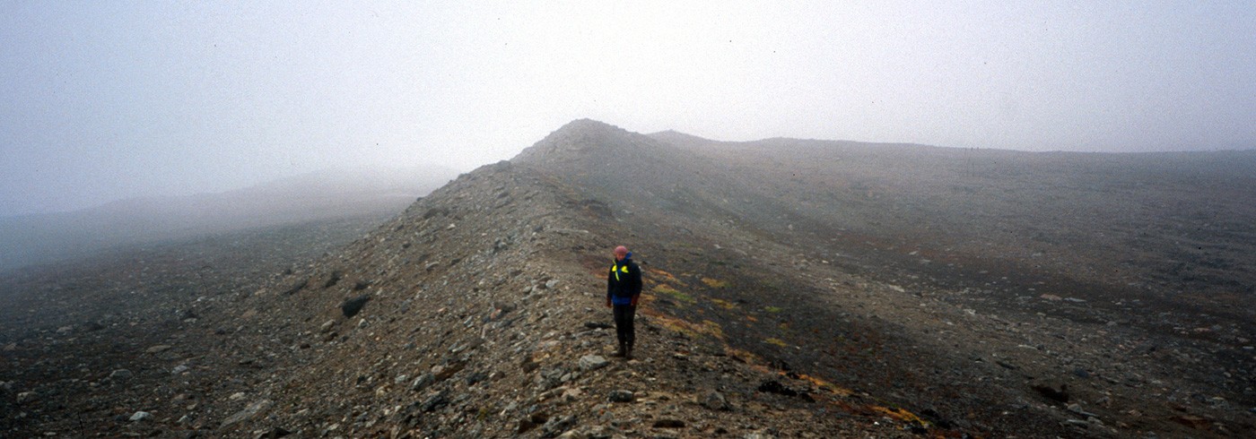
Two samples of glacially transported boulders were collected on the southern lowland, where the terrain much resembles that of the eastern lowland areas, but in addition has been overprinted by younger glacial activity, probably at the very end of the Weichselian (Hjort, 1981b). Along these southernmost parts of Store Koldewey, on the west coast just above the marine limit (the upper line of postglacial marine inundation), a lobe-formed moraine ridge reaching about 95 m.a.s.l. can be followed for a couple of hundred meters (photo 1). It is correlated with moraines further to the north at the same elevation. The deglaciation from these moraines is roughly dated by the age of the marine limit, which is known through data from the other side of Dove Bugt to be approx. 9.5 ka 14C-years Before Present (approximately 10,500 calendar years BP; Hjort, 1981b). Samples were now collected from one boulder on the crest of the moraine and from one outside (distally from) it, to test that assumption.
We plan to continue the work carried out this summer along other parts of the Northeast Greenland coast.
Acknowledgements
The leader of the German land group together with which the field work was carried out was Bernd Wagner, University of Leipzig. Ole Bennike, Copenhagen, is thanked for good companionship in the field.