
Approaching Milorgfjella on the autobahn. The four wheeled car plus trailer loaded up for the ‘”lightweight” expedition. The two snowmobiles and fuel took up most of the space on the cars. Photo: Karin Winarve
Learning from our success using both the cars and snowmobiles to access sites during the fieldwork in Tottanfjella, it was decided to make a speedy return journey to Milorgfjella with the snowmobiles. This would hopefully allow us to visit the high elevation, summit sites we were unable to access during the first visit.
In order to fit the snowmobiles and fuel on the cars, we had to significantly reduce the camping gear and go ”lightweight”. We were a team of just five for this trip. We took smaller mountaineering tents, and we cut out all luxuries – including the mess tent. We packed and strapped the cars on Thursday (9 February) evening, setting off early on Friday 10 February.
Milorgfjella is a little over 260 km from Wasa and it takes a whole day just to travel there. Much of this follows a well established route created and used by the German Alfred Wegener Institute (AWI), each year transporting equipment from their Neumayer station at the coast to their Kohnen station up on the high plateau. Thankfully for us the weather and snow conditions made for a fast journey. In addition to this the German convoy of powerful tracked vehicles towing containers on sleds back to Neumayer had just passed our route earlier in the day, creating an ”autobahn” which made the journey even faster, and enabled us to bring the heavily loaded cars up to 2,000 metres above sea level. Here we set up camp…
We arrived and began building our camp at around 20:30. It was -27 °C, and the sun was beginning to sink below the horizon. This biting cold combined with the high altitude made even the simplest of tasks hard work. We would regularly need to take a break from setting up a tent, or starting up a stove and cooking dinner to take a run down the tracks, or do the penguin dance to warm ourselves up. Thankfully there was a lot of snow digging to be done – a nice task for keeping warm.

Our wee camp up at 2,025 m on the plateau. To protect the small tents from the wind we dug a tent space about 1 m deep for each of the tents. It may not look like -27 °C… But it got even colder once the sun dropped behind the horizon. Photo: Karin Winarve

Eating dinner quickly before it froze! As well as digging tent spaces we also dug out a kitchen area. The stoves are best kept sheltered from the wind, as are we. Photo: Ola Eriksson
After setting up camp and, having eaten dinner (our noodles froze within minutes of being removed from the stove, so if you wanted to eat warm food, you ate quickly!) we wasted no time in heading to bed, knowing that getting into two sleeping bags (one inside the other) with a bottle of hot water was the only way to stay warm!
The following morning we set off on snowmobiles to visit three sites we had highlighted on the satellite images as potential sample sites. It took no time at all to reach the first site, Lauringrabben, a small ”wannabe” nunatak just emerging from the ice. The bedrock here was a highly weathered. We spent the best part of an hour scouring the small nunatak for possible samples but didn’t find anything. We started to worry that all this effort to return here was for nothing.
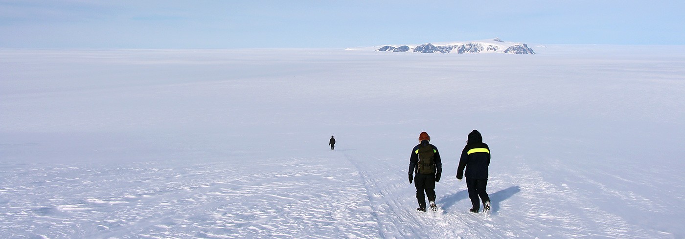
Our selected sites were close to one another and we could see our two other sites from Lauringrabben. These were the summits along the Milorgfjella range. At both Milorgfjella and Tottanfjella, where we have sampled so far, the mountains (nunataks) form something of a barrier to the ice flowing from the interior of the Antarctic Ice Sheet out to the coast. As such the ice surface on the southern side is at around 2,000 metres above mean sea level, and the present day ice surface is typically only 20–30 m below the summits. Yet the northern sides of these nunataks commonly form 500 m high vertical cliff faces with the ice surface at around 1,500 metres above sea level. The summits that seemed so daunting on our first visit here (when we approached from the north), are much easier when approached from the south.

Approaching the nunataks from the southern side is much easier! Along the mountain range (to the left of the photo) the ice surface is flush with the edge of the nunataks. Otherwise, the ice surface is within about 30 m (vertically) from the summits. Photo: Jennifer Newall

The summits are mostly plateau-like, so it really is an easy stroll from the ice onto the summits. This is in sharp contrast to the steep, jagged ridges we faced when camped below the cliffs. To give a sense of scale to the dramatic scenery, are you able to spot Ola and Jenny searching for samples along the top? Photo: Ola Eriksson
Here our efforts were rewarded as we found glacially polished and smoothed surfaces almost everywhere, including very well preserved striations – scratches on bedrock created as the rocks in the ice pass over it. Sampling, like setting up camp, was more difficult than usual due to the cold and high altitude. We fared much better in these conditions than any of our electronic and battery-powered equipment, none of which decided to work. So we resorted to the traditional hammer and chisel to get our samples. There was something very special (almost magical) about wandering along the top of such dramatic and stunning cliffs. One of the many reasons I love this work so much!

The drill decided it was too cold to work, despite us having warmed it by the engine of the snowmobile, so we resorted to the traditional hammer and chisel technique to collect our samples. Photo: Jennifer Newall

Collecting samples in with hammer and chisel. Photo: Jennifer Newall
We returned to camp at around 16:00 due to deteriorating weather. We have been so fortunate with the weather this expedition, though it is not always sunny in Antarctica!
The following morning, we packed up camp and started the journey home. The driving is mostly very enjoyable with spectacular views all the time, be they the mountains of Milorgfjella slowly disappearing out of view, or the vastness of the ice sheet, when there is nothing to break the horizon. All in all, it was a monstrous effort to return to Milorgfjella but hopefully the data we can get from the samples collected (in compliment to what we already have from the first visit) will make it a very worthwhile effort.

It’s not always sunny in Antarctica! At the summit of Schivestolen, with the visibility quickly deteriorating we decided to call it a day and head back to camp. Photo: Jennifer Newall