Isla de los Estados – Quaternary geology and palaeoclimatology at the end of the world
28 November 2005 - 16 December 2005
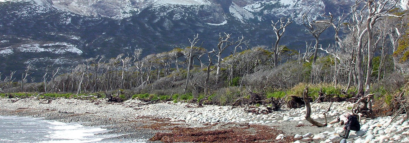
The storm-ridden beach, the windswept Nothofagus-forest and the rugged mountains at the camp by Bahía Colnett. Photo: Karl Ljung.
Introduction
The expedition in November–December 2005 to Isla de los Estados (Staten Island) off the south-eastern tip of South America was a cooperative venture between Lund University (LU) and Stockholm University (SU) in Sweden and the CADICCONICET institute in Ushuaia, Argentina. The size of the island is ca. 65 × 35 km, its geographical position roughly 54°45’S, 64°30’W and its highest peaks reach approx. 800 m a.s.l. Its bedrock geology and general morphology have been described by Dalziel et al. (1974) and Caminos and Nullo (1979).
The expedition travelled to the island with the chartered ketch Ocean Tramp. It left Ushuaia on Tierra del Fuego on 28th November and returned there on 16th December. The total number of field workdays was 16, carried out from one field camp in Bahía Colnett and, based on the boat, from anchorages in Puerto Basil Hall, Puerto Cook (picture 2), Puerto San Juan del Salvamente and Bahía Crossley. A one day visit was also made to the small Isla Observatorio north of the main island.
The scientific crew consisted of five Swedish researchers (Svante Björck, Christian Hjort, Karl Ljung and Per Möller from LU, and Barbara Wohlfart from SU) and five Argentinians (Jorge Rabassa, Juan Federico Ponce and Adrian Schiavini from CADICCONICET in Ushuaia, Fidel Roig from IANIGLA-CONICET in Mendoza, and Oscar Martinez from Universidad Nacional de la Patagonia-San Juan Bosco in Esquel). In addition to this the ketch had a crew of three (with captain Charlie Porter) and an Argentinian medical doctor (Enrique Pianzola).
The expedition’s aim was threefold; (1) to anchor the Swedish palaeoclimatic “ATLANTIS”-project (Greenland, Iceland, Faroe Islands, Azores, Grenada, Tristan da Cunha, e.g. see Björck et al. 2002, Andresen et al. 2004, Andresen and Björck 2005, Björck et al. 2006, Andresen et al. 2006, Ljung et al. 2006) onto the southern parts of the South American continent; (2) to connect earlier Swedish and Argentinian glacial- and climate history reconstructions from the Antarctic Peninsula (e.g. Björck et al. 1996, Hjort et al. 2003, Ingolfsson et al. 2003) with equivalents from north of the Drake Passage, in southernmost South America; (3) to extend this type of palaeo-information such as that already available from the Tierra del Fuego mainland (see references below) to the peripherally situated and in this context only superficially studied Isla de los Estados.

The north coast of Isla de los Estados at Puerto Cook as seen from the approaching Ocean Tramp. Photo: Svante Björck
Earlier studies have shown that at one time glaciers originating in the southernmost Andes reached east to and beyond the present Atlantic coast (e.g. Nordenskjöld, 1898, Caldenius, 1932, Auer, 1956, Malagnino and Olivero, 1999, Rabassa et al., 2000, Sugden et al., 2005). However, the last time they did so on a broad front may have been 1 million years ago – and the ice-fronts did not reach the Atlantic at all during the so-called Last Glacial Maximum (LGM) around 20,000 years ago (Rabassa et al., 2000, Sugden et al., 2005). On the first glaciation map ever published for southern South America, Otto Nordenskjöld (1898) envisaged an ice cap which, covering the Andes and much of the (due to lower sea level) dry shelf areas southeast of Tierra del Fuego, also included Isla de los Estados. A study of topographic maps, satellite images and aerial photos of the island also show it pitted with glacial cirques and truncated by overdeepened glacial basins (mini-fjords) – in contrast to which its higher areas (above ca. 300 m) show a distinct nunatak topography. Thus the island seemed a promising working area for a glacial geologist.
As for the vegetation history of Isla de los Estados, which today is covered below the treeline at approx. 300 m by a combination of primeval Nothofagus forest and bogs, not too much is known. The flora and vegetation of the island were described by Dudley and Crow (1983) and included in Moore’s Flora of Tierra del Fuego (1983), but the only palaeobotanical work so far available from here is by Johns (1981). This was based on three undated peat cores from the Bahía Crossley area. However, from mainland Tierra del Fuego much palaeovegetational work has been done over the years, e.g. by Auer (1958), Heusser (1989, 1998) and Markgraf (1993a, b). The development can be said to start with the post-LGM deglaciation around 17,000 years ago (e.g. Hulton et al., 2002) and thereafter includes climatically based fluctuations between steppes, forests and so called Magellanic moorlands.
On Isla de los Estados our expedition studied the glacial history, as illustrated in the field by glacial erosion and various forms of deposition, through geomorphological and stratigraphical work, including the sampling for dating. Palaeoclimatic records were sampled by coring lake sediments and peat bogs and through dendrochronological work on both living Nothofagus trees and old logs preserved in the peat.
Glacial geomorphology and sedimentology
Our main work on glacial geomorphology and sedimentology was conducted at Bahía Colnett (figure 1). Here four moraines form highly arched ridges, 5–15 m high, one of them damming Lago Lovisato (moraine C, figure 1). The small Lago Galvarne to the north is, however, dammed by a pronounced beach ridge. Moraines A and B are eroded by the sea at the recent shoreline, and their tentative former continuation out into Bahía Colnett is indicated in figure 1. The configuration of these moraines show that they were formed at temporary stillstands during the recession of an outlet glacier emanating in the mountains to the south, thus representing only local glaciation on Isla de los Estados. Minimum ages for the moraines, and thus for the deglaciation, are given by the lowermost 14C datings of organic deposits from lake cores. For Lago Galvarne it is 16,500 cal yr BP (calculated years before present) (figure 1: coring point 1), which gives the minimum age for moraine B. For the small lake southwest of Lago Lovisato it is 16,000 cal yr BP (figure 1: coring point 3), which then possibly gives the minimum age for moraine D. The moraine indicated on the western shore of the Cabo Colnett peninsula (figure 1) is a lateral one, from an outlet glacier flowing out of Puerto Parry into Bahía San Antonio.

Air photo of the Bahía Colnett–Lago Lovisato area with its succession of moraines. The configuration of the four successively younger ice-marginal moraines (A–D; hatched–punctuated lines) suggest that the Lago Lovisato valley was once occupied by an outlet glacier from ice fields in the mountains to the south. Stratigraphic sections in the shore cliffs are marked by triangles; glacial tills in the sections indicate an ice-flow direction (arrow) out of the Lago Lovisato valley. Thin stippled lines parallelling the present shore and towards Lago Lovisato indicate the position of a series of beach ridges with crests situated some 3–4 m above the present shoreline. Coring points 1–3 are indicated with open circles. The camp was situated close to the beach, northeast of coring point 1.
Eastward, in the direction of Puerto Roncagli (figure 1), wave erosion has formed a 10–25 m high cliff, exposing the glacigenic sediments of the area (picture 3). Documented sedimentary sequences (triangles at the coast in figure 1) give a local stratigraphy of the area, which at sea level starts with laminated silt and clay, probably representing annual varves. These glaciolacustrine sediments are overlain by thick diamict units, being both massive and shear laminated. The diamicton is frequently interbedded with sorted sediments, often showing glacial deformation structures. The lower part of the diamicton also has large inclusions of silt and clay in its lower part, interpreted to derive from the underlying glaciolacustrine sediments. The long-axis orientation of pebble clasts shows a transport direction from SSW, suggesting that the diamicton was deposited beneath a glacier that came out of the Lago Lovisato valley, thus a product of local glaciation. Maximum ages of this glaciation will be given by pending OSL (Optically Stimulated Luminescence) datings, and its minimum age by 14C datings of the blanketing peat.

Per Möller excavating the thick glacial deposits on the eastern side of Bahía Colnett. Photo: Svante Björck.
Another important locality with Quaternary sediments was located in the inner part of Bahía Crossley. Here sequences of interbedded fluvial and aeolian sediments are draped by a diamicton with a strong long-axis orientation of elongated stones in it. However the genetic interpretation of this diamicton is not clear; it could either be interpreted as a glacial till or as a colluvium, i.e. a debris flow from adjacent high areas. The age of the fluvial and aeolian sediments will be determined by 14C datings on organic remains and by OSL dating on the sediment itself, and a minimum age of the covering diamicton should be given by 14C dating the peat on top of it.
Lake sediment and peat stratigraphy
To reconstruct the palaeoclimatic development of Isla de los Estados since the last ice retreat, four main peat bog/lake sites were cored and sampled with a so-called Russian chamber corer. Three of these are situated in the Bahía Colnett area (figure 1) and the fourth one in Bahía Crossley.
The northernmost site, Lago Galvarne, was cored from several points in the lake and from the peat bog surrounding it. The most complete stratigraphy was found in the bog south-west of the lake, where 7.5 m of sediments were retrieved (figure 1: coring point 1). The stratigraphy is complex, with a mix of peat, lake sediments and marine sediments, and the peat at the bottom of the cored profile is dated to 16,500 cal yr BP. The high bottom age and the complexity of the sediments imply that this key site can be used both for dating the deglaciation and for unfolding the general palaeoenvironmental development thereafter, including the sea level history. Because of the highly variable character of the deposits, an array of different methods will be used to analyse these sediments.
Moraine ridge C (figure 1) is covered by 4 m of peat at the crest of the ridge, but a more than 7 m thick peat sequence was found on its northern slope. A complete sequence (7.1 m) of it was cored at coring point 2 (figure 1). The stratigraphy implies that peat humification has varied considerably over time and 14C dating shows that the bottom of the sequence is older than 13,000 cal yr BP. Such a high bottom age for a peat profile is rare, and in combination with the variable stratigraphy this may turn into a unique palaeohydrological archive.

A sediment core with lake sediments (the grey siltgyttja) on top of the brown peat. This is evidence for a significant hydrologic change: the peat bog environment is replaced by a lake. Photo: Barbara Wohlfarth
Echosoundings of the large Lago Lovisato basin, carried out from our Zodiak rubber dinghy, showed that the northern part of the lake is shallow, only ca. 3 m deep, and that the southern part has several sub-basins, of which the deepest is 26 m. These were regarded impossible to core due to the high wind fetch from the south and the water depth. Therefore a small lake southwest of Lago Lovisato, here called Laguna Cascada, was cored instead (figure 1: coring point 3). Since the coring was performed from the quagmire that surrounds the lake, the uppermost part of the sequence consists of peat. Below the peat we cored >4 m of lake sediments with a glacial varved clay at the bottom. The transition between the varved clay and the organic lake sediments is dated to ca. 16,000 cal yr BP. Considering the relatively thin sequence in relation to the old bottom age, one would suspect that some sediments are lacking. However there are no signs of any clear hiatuses or erosional discordances, which instead implies a low sedimentation rate, in the order of only 0.25–0.3 mm/year. The lithology is very variable, with different types of gyttja units, some clearly laminated, others rich in gravel/sand clasts and tephra layers. The sequence is highly interesting from a palaeoclimatic viewpoint and detailed geochemical analyses are under way, as well as diatom analyses.
The fourth cored and sampled sequence is from 0.5 km inside the eastern part of Bahía Crossley, where Johns (1981) had reported the occurrence of an almost 10 m thick peat sequence, but without age control. After reconnaissance corings in the area a promising spot was found. Here it was possible to penetrate approx. 11 m into swamp peat, variably humified, including a few metres at the bottom with a mix of peat and reworked fluvial sediments. The oldest age obtained from this sequence is ca. 9 000 cal yr BP, but the upper 8 m of undisturbed stratigraphy comprises only ca. 7 500 cal years. Detailed analyses of organic matter and magnetic susceptibility have already been carried out and will be complemented by pollen and macrofossil analyses.
Summary
To sum up, the results of the 2005 expedition to Isla de los Estados look very promising. The different data sets imply that we will be able to reconstruct a more or less complete history of climatic, glacial, vegetational and sea level development from the Last Glacial Maximum until the present time. The sampled material is being analysed both in Sweden and in Argentina, and a group of Swedish and Argentinian senior researchers are directly involved in the project, as well as an Argentinian PhD student, Marilen Fernandez, and a German post-doc, Ingmar Unkel.
We think that this work will further strengthen the long history of Swedish-Argentinian scientific cooperation, originating from Otto Nordenskjöld’s expedition to Tierra del Fuego and Patagonia in 1895–97.