Eurasian ice sheets – Taymyr Peninsula
The “Eurasian Ice Sheets” project is mainly financed by the EU and is also assisted by the Swedish Natural Science Research Council (NFR) and the Royal Swedish Academy of Sciences. It works under the umbrella of the European Science Foundation programme QUEEN (Quaternary Environment of the Eurasian North), investigating the extent of glaciation, in time and space, in the Eurasian Arctic, from the Kola Peninsula eastwards to Taymyr and beyond. The time interval studied is primarily the last glacial cycle, i.e. the last ca. 125,000 years, with emphasis on the situation during the last global glacial maximum ca. 20,000 years ago. An up-to-date knowledge of the latter time period is especially important for global climate modelling- both backwards and forwards in time – as that glacial maximum event represents the extreme cold end of the climatic scale!
The project on Taymyr was launched in 1996 and, on a larger scale, continued in 1998 and now in 1999. A comprehensive background to it was presented in the Swedish Polar Research Secretariat’s year-book for 1998.
The 1999 field-work
The field-work on Taymyr in 1999 was carried out within the same expedition, ”Taymyr-1999”, as the bedrock work performed by a group under David Gee, Uppsala University. The expedition arrived at Dikson, at the mouth of the Jenisey River, on 21 July, by charter flight from St. Petersburg. We left for home on 18 August.
The Quaternary investigations were carried out by two teams from two base camps. One group (Hjort, Bolshiyanov, Alexanderson, Antonov) worked in the Astronomical Lakes area on north-western Taymyr, ca. 100 km inland from the coast, from a base camp on the Mammoth River (75°17’N, 96°19’E). The aim here was to continue mapping the so-called ”Isayeva Line”, an ice-marginal zone formed by an ice-sheet spreading from the Kara Sea shelf and marking the last major glaciation of the Taymyr Peninsula, and to study its different stages and date them. In 1998 this ice-marginal zone had been investigated further north (in the Barometric Lake and White Lake areas), where its youngest parts are represented. Now the oldest stages were being studied.
The second group (Möller, Fedorov, Jönsson, Pavlov) worked on northernmost Taymyr, on the Chelyuskin Peninsula, from a bas e camp on the Angelica River (77°21’N, 102°41’E). Their main task was to study the sediments and morphological features (e.g. elevated shorelines) outside hut rather close to the ”Isayeva Line” to, among other things, establish the maximum possible age of the ice-margin here.
The field-work in both areas went well and the missions were completed under reasonably good weather conditions. As there were no camp-shifts by helicopter this summer, light-weight camps were used on some longer tours away from the base camps.
Preliminary results
Our work in 1996 (Möller et al. 1999) and German-Russian work carried out in the same area (Hahne & Melles 1999; Ebel et al. 1999) had shown that, with the possible exception of mountain glaciers in the high eastern Byrranga Mountains, no glaciation had affected the central parts of the Taymyr Peninsula since the early part of the last (Weichselian) glaciation, i.e. since at least 40,000 years ago. Prior to that, however, large amounts of glaciomarine sediments derived from glaciers in the north had been deposited in the Taymyr Lake basin. Work in other parts of the QUEEN-area, supported by glaciological modelling, had also indicated that it was unlikely that any substantial ice-sheet had covered the eastern Kara Sea region as late as during the last glacial maximum ca. 20,000 years ago ( Svendsen et al. 1999), suggesting that only rather insignificant (thin) ice-caps may have existed in north-westernmost Taymyr at that time.
Thus, most ”surrounding” evidence seems to indicate that the ”Isayeva Line” should date from the early part of the last glacial cycle- and this has also been supported by so-called luminescence da ting of sediments from the large glacial lakes to the south, which were dammed by, and thus contemporaneous with, this ice. However, 14C-datings of mollusc shells from material melted out of the ice from the youngest and thinnest ice-sheet reaching the ”Isayeva Line”, indicates that this last ice did not advance on to present land until after ca. 20,000 years ago, that is during the last glacial maximum. Other 14C-dating of plant material, shows de glaciation at this ice front as late as ca. 9 500 years ago, which is exactly the time glaciers finally collapsed all over the Arctic. All this indicates a last, thin hut rather extensive ice-sheet infringing on to north-westernmost Taymyr during the last glacial maximum.
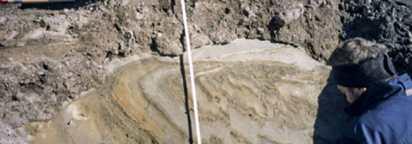
Work in the Astronomical Lakes area this summer was mainly concerned with morphological mapping and stratigraphic definition of different stages in the formation of the ”Isayeva Line” and of the glacial lakes dammed by the ice. The latter were very extensive, and the oldest/deepest one in this area reached up to the ice-front with its surface standing ca. 120 m above the present sea level. As was noted in 1998, these lakes probably drained southwards in to the Taymyr Lake basin, whereas today most rivers on central Taymyr and all rivers on western Taymyr drain directly towards the Kara Sea. Systems of river terraces connecting the ice-margin with younger/lower level glacial lakes were also studied, as were the formation of thermokarst depressions within the ice-marginal zone – and their probable ”re-use” as glacial basins by the next glacial advance. Another interesting feature was a probably redeposited marine sediment, rich in boulders and shells, which underlies distal sediments outside the ”Isayeva Line”. This may be a till deposited by early Weichselian or older ice which reached much further south.
Work on the Chelyuskin Peninsula showed that the ca. 350 m high mountains there had been overridden by ice at least once from the west, as proven by the occurrence on their summits of crystalline erratic boulders originating from the Kara Sea. A till, most probably also from a Kara Sea based ice-sheet, was found at lower elevations on top of marine sediments, in several sections. This till in turn is often overlain by marine sediments which show no sign of glacial overriding and which occur up to 60-70 m above the present sea level, not far outside the ”Isayeva Line”. These marine sediments contain shells of molluscs which do not live in the very cold waters of the present north-eastern Kara Sea today like the scallop Chlamys islandicus. This indicates that they either date from the so-called Eemian interglacial some 125,000 years ago, or from some early Weichselian interstadial. The high marine limit is the result of isostatic (ice-load derived) down-pressing of the land during the preceding Saale glaciation, when a thick ice-sheet must have covered most of the Taymyr Peninsula, including its central parts. The above mentioned erratic blocks on the mountains and the lower of the two tills were probably laid down then. The marine limit during the present so-called Holocene interglacial is very low, probably equivalent to the present coastline. This may be due to incomplete isostatic unloading (rising of the land) because much of the Weichselian glacier ice is still there, incorporated in to the permafrost.
The geological field data collected during the expeditions of 1998 and 1999 should, in combination with an extensive dating programme using the 14C-, U/Th-, luminescence and ESR (electron spin resonance) methods on shells, plant material and the sediments themselves, allow us to put together a modern picture of events on Taymyr during the last glacial cycle. Thereby our knowledge of the eastern flank of the huge Fennoscandian-Barents Sea-Kara Sea ice-sheet complex should attain state-of-the- art standards, and in combination with all other results from the ”Eurasian Ice Sheets”/QUEEN work, the updated picture of glaciation in northern Eurasia should constitute a much more solid base for climate modelling than has hitherto been available!
Dates
21 July–18 August 1999
Participants
Principal investigator
Christian Hjort
Department of Quaternary Geology, Lund University
Sweden
Helena Alexanderson
Department of Quaternary Geology, Lund University
Sweden
Oleg Antonov
Arctic & Antarctic Research Institute
St. Petersburg, Russia
Dmitri Y. Bolshiyanov
Arctic & Antarctic Research Institute
St. Petersburg, Russia
Grigorij Fedorov
Arctic & Antarctic Research Institute
St. Petersburg, Russia
Charlotte Jönsson
Department of Quaternary Geology, Lund University
Sweden
Per Möller
Department of Quaternary Geology, Lund University
Sweden
Maxim Pavlov
Arctic & Antarctic Research Institute
St. Petersburg, Russia
References
Ebel, T., Melles, M. and Niessen, F. (1999). Laminated sediments from Levinson-Lessing Lake, northern central Siberia – a 30 000 year record of environmental history. Land-Ocean Systems in the Siberian Arctic. Kassens, H. et al. (ed.) Springer Verlag, Berlin, 425-435.
Hahne, J. and Melles, M. (1999). Climate and vegetation history of the Taymyr Peninsula since Middle Weichselian time – palynological evidence from lake sediments. Land-Ocean Systems in the Siberian Arctic. Kassens, H. et al. (ed.) Springer Verlag, Berlin, 407-432.
Möller, P., Bolshiyanov, D.Y. and Bergsten, H. (1999). Weichselian geology and palaeoenvironmental history of the central Taymyr Peninsula, Siberia, indicating no glaciation during the last global glacial maximum. Boreas 28, 92-114.
Svendsen, J. l., Astakhov, V. l., Bolshiyanov, D .Y., Demidov, I., Dowdeswell, J.A., Gataullin, V., Hjort, C., Hubberten, H. W., Larsen, E., Mangerud, J ., Melles, M., Möller, P., Saarnisto, M. and Siegert, M.J. (1999). Maximum extent of the Eurasian ice sheets in the Barents and Kara Sea region during the Weichselian. Boreas 28, 234-242.