Lomonosov Ridge off Greenland (LOMROG) 2007: Coring and highresolution geophysical mapping
12 August 2007 - 17 September 2007
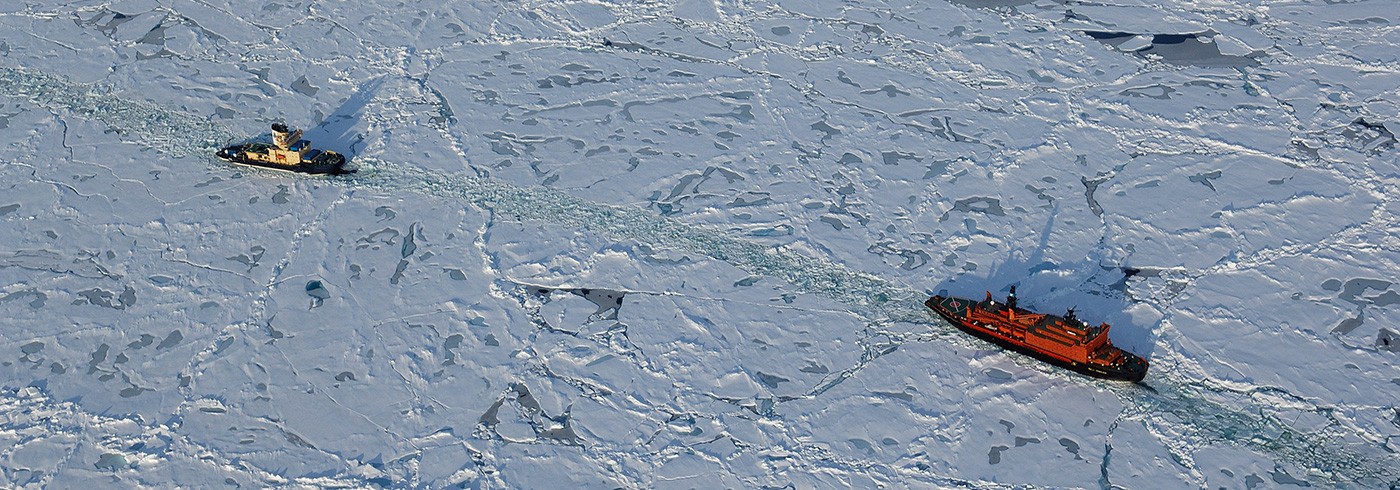
The new Russian nuclear icebreaker 50 let Podedy supporting Oden in the areas of the Arctic Ocean north of Greenland. Photo: Martin Jakobsson.
Introduction and background
The Arctic Ocean north of Greenland is virtually unexplored due to predominantly heavy sea ice conditions that have made the area by and large inaccessible. Icebreakers have previously never attempted to reach the southern tip of the submarine Lomonosov Ridge that extends towards the northern Greenland continental margin. Among the scientific ice drift stations, only the GreenICE camp in 2004 has investigated a fragment of the southwesternmost part of the ridge (Kristoffersen and Mikkelsen, 2006). This ice-infested area of the Arctic Ocean was the focus for the Lomonosov Ridge off Greenland (LOMROG) 2007 expedition as it is probable that it holds answers to key questions regarding ocean circulation and glacial history, such as the question whether immense Antarctic style ice shelves existed in the Arctic Ocean during past glacial periods. Previous expeditions to the Lomonosov Ridge with Swedish icebreaker Oden in 1996 and the US nuclear submarine Hawkbill in 1999 demonstrated the occurrence of glacial ice grounding down to 1 000 m present water depth at about 87°N (Siberian side) on the ridge crest (Jakobsson, 1999, Polyak et al., 2001). If this ice grounding event resulted from a much debated (e.g. Mercer, 1970), but supposedly coherent and large floating ice shelf, the Lomonosov Ridge north of Greenland should also be scoured. To test the hypothesis of a huge Arctic Ocean ice shelf, LOMROG mapped the Lomonosov Ridge and Morris Jesup Rise north of Greenland as well as the Yermak Plateau north of Svalbard using the new multibeam bathymetric sonar and chirp subbottom profiling system installed on the Oden during the spring of 2007 (picture 2). In addition, sediment cores were taken from the surveyed areas for palaeoceanographic studies, and sediment samples were collected from “dirty” patches of drifting ice floes for modern provenance studies. With this material, the history of the Arctic Ocean circulation and sea ice cover will be addressed, such scientific questions being of particular relevance in the context of the present trend of diminishing Arctic Ocean sea ice cover, where September in the year of 2007 showed the aerially smallest extent ever measured over the last 28 years (National Snow and Ice data Center)

Overview of the coring operations on the Oden’s aft deck. The up to 12 m long and 1.5-ton heavy piston corer was launched using a cradle gliding on a rail mounted on the aft deck. This new launching system was installed just prior to the expedition in Landskrona while Oden was in dry dock. It proved to be excellent and significantly reduced the coring station times compared to previous expeditions. Photo: Martin Jakobsson.
However, it should be noted that in the LOMROG operating area north of Greenland severe sea ice conditions were encountered with 10/10 ice cover and sometimes ~4 m thick multiyear floes.
The second major component of the LOMROG expedition consisted of the Danish Continental Shelf Project (Marcussen et al.). This project collected seismic reflection profiles and bathymetry in order to acquire the base data needed to eventually put forward an Article 76 of United Nations Convention of the Law of the Sea (UNCLOS) claim for a new legal definition of Denmark’s continental margin north of Greenland. Furthermore, LOMROG included a number of scientific subprojects. These comprised studies of the return flow of Atlantic water and deep water exchange between the Eurasian and Amerasian Arctic Ocean basins (Anderson et al.), the role of sea ice in the transport of CO2 from the atmosphere to the ocean (Rysgaard et al.), distribution of mercury in the atmosphere and ocean (Gårdfeldt et al.), and the Arctic Ocean gravity field (Marcussen et al.).
The LOMROG expedition constitutes a project in the Arctic Palaeoclimate and its Extremes (APEX) research network programme endorsed by the International Arctic Science Committee (IASC) and the ICSU/WMO Joint Committee for the International Polar Year 2007–2008 (IPY).
LOMROG ship based work and preliminary results
Despite severe sea ice conditions Oden, supported by the newest Russian nuclear icebreaker 50 let Pobedy, managed to reach the previously unexplored southernmost tip of the Lomonosov Ridge north of Greenland to conduct scientific work (see map and picture 1). Large pressure ridges and thick multiyear sea ice prevented mapping with the multibeam and subbottom profiler along straight predefined tracks. The surveys were instead dictated by the few existing crack systems in the sea ice and openings in the large pressure ridges that allowed 50 let Pobedy and Oden to break through. Another problem for the acoustic mapping was the crushed ice in the wake of 50 let Podedy, which reduced the data quality significantly, in addition to the noise from the icebreaking. This ice slush was pressed underneath the hull of Oden and occasionally completely covered the hullmounted multibeam and subbottom acoustic transducers. However, even though LOMROG faced certain difficulties in the sea ice over the Lomonosov Ridge, valuable geophysical data were collected. In addition, six sediment cores were retrieved from this area, both from the shallow ridge crest and the slope towards Amundsen Basin (see map). Preliminary analysis of the multibeam and subbottom data show glacial erosion at water depths shallower than approximately 800 m on the Lomonosov Ridge and the sediment cores retrieved from the glacially scoured sea floor contained diamicton. A first hand analysis seems to support the hypothesis of glacial ice grounding on the shallow ridge crest.

LOMROG expedition route and scientific station work.
The Lomonosov Ridge programme was shortened due to damage of 50 let Pobedy’s propeller blade in the hard ice conditions. The next target for LOMROG was the Morris Jesup Rise where Oden had to operate without support from the Russian nuclear icebreaker. The sea ice cover was here 10/10 as in the Lomonosov Ridge area, although large pressure ridges were less abundant. A completely new multibeam survey technique was invented that proved very successful in extreme ice conditions. This technique, named “pirouette surveying”, involved Oden stopping and turning around in a half circle while acquiring multibeam data whenever an open to semi-open lead in the pack ice was encountered (picture 3). The idea was to cover a 360° sector around the ship equal to the multibeam swath width, which was commonly between 3–4 times the water depths, although sometimes we achieved a swath up to 5 times the water depth. Occasionally the ship was rotated 360° to increase the resolution of the mapped area underneath the ship. After one “pirouette” was completed, Oden broke ice using its full capacity to the end of the multibeam swath coverage, where a new pirouette was carried out. The Morris Jesup Rise’s northern slope and shallow crest was successfully mapped using this technique. The data reveal large iceberg scours down to a water depth of approximately 1 050 m, so far the largest and deepest iceberg scours mapped in the Arctic Ocean (picture 4). The coring programme on the Morris Jesup Rise targeted undisturbed sediment sections for palaeoceanographic studies as well as the largest ice scour ever mapped. The purpose of coring the ice scour was to investigate the age of the icegrounding event that caused it. This can be achieved by dating the sediments that accumulated since the scouring event. The newly installed chirp sonar profiler provided the critical data in order to precisely locate optimal coring sites. Altogether, four cores were retrieved from the Morris Jesup Rise. All sediment cores were directly logged on board Oden with a Multi Sensor Track Core Logger (MSCL) measuring sediment bulk density, p-wave velocity and magnetic susceptibility. After core logging, the cores were split and described.

Photo showing the data acquisition window of Oden’s EM120 multibeam system. The example shows how bathymetric data was collected in a 360° sector around the ship, referred to as “pirouette surveying” (see text for explanation). This way of carrying out multibeam mapping worked well in hard ice conditions where the heavy ice breaking otherwise significantly disturbed the data acquisition. Photo: Martin Jakobsson.
After completion of the scientific programme on the Morris Jesup Rise, an oceanographic section across the western Fram Strait was conducted. Conductivity Temperature Depth (CTD) measurements and water sampling were carried out along this section at regularly spaced stations (see map and Anderson et al.). The marine geological/geophysical programme was working in close cooperation with the oceanographic component, for example, the CTD data are used to calculate sound speed profiles of the water column that, in turn, are used to calibrate the multibeam sonar in order to get “true” depths of the sea floor.
In 2005, the US icebreaker Healy crossed the Yermak Plateau during the Healy-Oden Trans Arctic Expedition (HOTRAX) and the Beringia expedition and mapped portions of the shallow crest with their Seabeam 2112 multibeam sonar (Darby et al., 2005, Jakobsson et al., 2005). On the way to the next LOMROG major survey area, the East Greenland Ridge, Oden’s route was carefully offset to the Healy 2005 track on the Yermak Plateau in order to extend the previous multibeam survey. The new geophysical mapping data collected with Oden’s EM120 multibeam and SBP120 chirp sonar profiler revealed details that were previously not seen and further analysis may elucidate the behaviour of the Barents and Kara Sea ice sheet during previous glaciations.

Leonid Polyak describing a section of a sediment core. Photo: Martin Jakobsson
The last area to be surveyed during the LOMROG expedition was the East Greenland Ridge (see map) where a large part of the geophysical survey was carried out in open sea with only some occasional scattered ice floes. Only in the western part of the surveyed area close to the shelf break, was icebreaking required in 7 to 9/10 sea ice cover. The East Greenland Ridge survey was entirely a part of the Danish Continental Shelf Project and consequently those results are further reported by Marcussen et al.
The LOMROG expedition, which started 11 August in Tromsö, Norway, was completed on 16 September in Longyearbyen, Svalbard. The multibeam sonar and subbottom profiler were operated continuously along the approximately 6 900 km long expedition track. Two multibeam operators were always on watch 24 hours 7 days a week and the Swedish and Danish teams collaborated by assigning personnel to this task from both groups. The data quality vary largely with the sea ice conditions; although we learned that high quality data can be collected even during the hardest possible conditions using the “pirouette technique”. LOMROG was the first icebreaker expedition to reach the southern Lomonosov Ridge north of Greenland.

3D-view of the multibeam mapped Morris Jesup Rise. The International Bathymetric Chart of the Arctic Ocean (IBCAO) grid model is shown (blue grid) as a comparison to the new detailed multibeam bathymetry.